You are here: Home > Network List > TA - USArray Transportable Network (new EarthScope stations) Stations List
> Station E12A Beaver Dam Saddle, Pierce, ID, USA > Earthquake Result Viewer
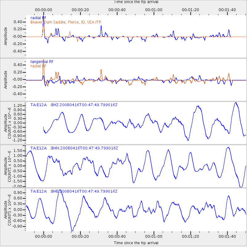
E12A Beaver Dam Saddle, Pierce, ID, USA - Earthquake Result Viewer
*The percent match for this event was below the threshold and hence no stack was calculated.
| Earthquake location: |
Tonga Islands |
| Earthquake latitude/longitude: |
-18.6/-175.7 |
| Earthquake time(UTC): |
2008/04/16 (107) 00:35:48 GMT |
| Earthquake Depth: |
10 km |
| Earthquake Magnitude: |
5.6 MB, 6.3 MS, 6.3 MW, 6.3 MW |
| Earthquake Catalog/Contributor: |
WHDF/NEIC |
|
| Network: |
TA USArray Transportable Network (new EarthScope stations) |
| Station: |
E12A Beaver Dam Saddle, Pierce, ID, USA |
| Lat/Lon: |
46.42 N/115.57 W |
| Elevation: |
1555 m |
|
| Distance: |
84.4 deg |
| Az: |
37.073 deg |
| Baz: |
235.723 deg |
| Ray Param: |
$rayparam |
*The percent match for this event was below the threshold and hence was not used in the summary stack. |
|
| Radial Match: |
67.68499 % |
| Radial Bump: |
328 |
| Transverse Match: |
49.12391 % |
| Transverse Bump: |
400 |
| SOD ConfigId: |
2504 |
| Insert Time: |
2010-03-06 18:11:32.251 +0000 |
| GWidth: |
2.5 |
| Max Bumps: |
400 |
| Tol: |
0.001 |
|
Signal To Noise
| Channel | StoN | STA | LTA |
| TA:E12A: :BHN:20080416T00:47:49.799016Z | 1.5044562 | 1.0086376E-6 | 6.7043334E-7 |
| TA:E12A: :BHE:20080416T00:47:49.799016Z | 2.061936 | 4.7842866E-7 | 2.3202887E-7 |
| TA:E12A: :BHZ:20080416T00:47:49.799016Z | 0.7643763 | 3.4373522E-7 | 4.4969374E-7 |
| Arrivals |
| Ps | |
| PpPs | |
| PsPs/PpSs | |


