You are here: Home > Network List > TA - USArray Transportable Network (new EarthScope stations) Stations List
> Station A21K Barrow, AK, USA > Earthquake Result Viewer
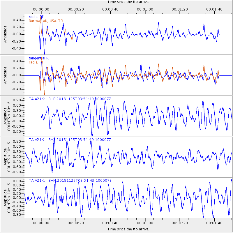
A21K Barrow, AK, USA - Earthquake Result Viewer
*The percent match for this event was below the threshold and hence no stack was calculated.
| Earthquake location: |
Caribbean Sea |
| Earthquake latitude/longitude: |
13.2/-81.2 |
| Earthquake time(UTC): |
2018/11/25 (329) 03:40:51 GMT |
| Earthquake Depth: |
10 km |
| Earthquake Magnitude: |
6.0 Mww |
| Earthquake Catalog/Contributor: |
NEIC PDE/us |
|
| Network: |
TA USArray Transportable Network (new EarthScope stations) |
| Station: |
A21K Barrow, AK, USA |
| Lat/Lon: |
71.32 N/156.62 W |
| Elevation: |
577 m |
|
| Distance: |
73.0 deg |
| Az: |
340.964 deg |
| Baz: |
99.553 deg |
| Ray Param: |
$rayparam |
*The percent match for this event was below the threshold and hence was not used in the summary stack. |
|
| Radial Match: |
50.420326 % |
| Radial Bump: |
392 |
| Transverse Match: |
62.565544 % |
| Transverse Bump: |
400 |
| SOD ConfigId: |
13570011 |
| Insert Time: |
2019-05-01 21:26:46.532 +0000 |
| GWidth: |
2.5 |
| Max Bumps: |
400 |
| Tol: |
0.001 |
|
Signal To Noise
| Channel | StoN | STA | LTA |
| TA:A21K: :BHZ:20181125T03:51:49.100007Z | 1.3959196 | 2.6652432E-7 | 1.90931E-7 |
| TA:A21K: :BHN:20181125T03:51:49.100007Z | 0.9534585 | 2.8504206E-7 | 2.989559E-7 |
| TA:A21K: :BHE:20181125T03:51:49.100007Z | 2.1142297 | 6.6878414E-7 | 3.163252E-7 |
| Arrivals |
| Ps | |
| PpPs | |
| PsPs/PpSs | |


