You are here: Home > Network List > TA - USArray Transportable Network (new EarthScope stations) Stations List
> Station 121A Cookes Peak, Deming, NM, USA > Earthquake Result Viewer
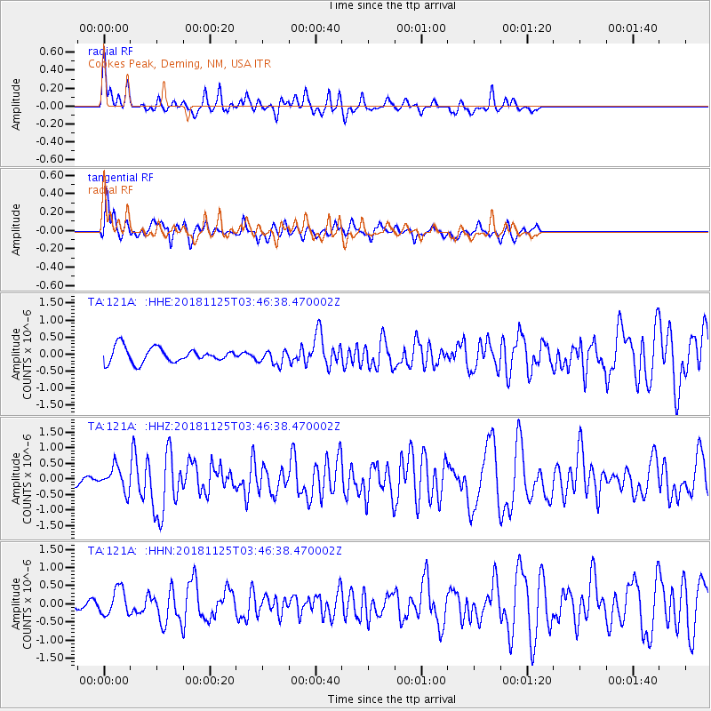
121A Cookes Peak, Deming, NM, USA - Earthquake Result Viewer
*The percent match for this event was below the threshold and hence no stack was calculated.
| Earthquake location: |
Caribbean Sea |
| Earthquake latitude/longitude: |
13.2/-81.2 |
| Earthquake time(UTC): |
2018/11/25 (329) 03:40:51 GMT |
| Earthquake Depth: |
10 km |
| Earthquake Magnitude: |
6.0 Mww |
| Earthquake Catalog/Contributor: |
NEIC PDE/us |
|
| Network: |
TA USArray Transportable Network (new EarthScope stations) |
| Station: |
121A Cookes Peak, Deming, NM, USA |
| Lat/Lon: |
32.53 N/107.79 W |
| Elevation: |
1652 m |
|
| Distance: |
31.1 deg |
| Az: |
312.798 deg |
| Baz: |
122.207 deg |
| Ray Param: |
$rayparam |
*The percent match for this event was below the threshold and hence was not used in the summary stack. |
|
| Radial Match: |
69.49655 % |
| Radial Bump: |
322 |
| Transverse Match: |
72.10463 % |
| Transverse Bump: |
400 |
| SOD ConfigId: |
13570011 |
| Insert Time: |
2019-05-01 21:26:47.011 +0000 |
| GWidth: |
2.5 |
| Max Bumps: |
400 |
| Tol: |
0.001 |
|
Signal To Noise
| Channel | StoN | STA | LTA |
| TA:121A: :HHZ:20181125T03:46:38.470002Z | 2.7179797 | 3.8393196E-7 | 1.4125638E-7 |
| TA:121A: :HHN:20181125T03:46:38.470002Z | 2.162404 | 3.6075718E-7 | 1.6683153E-7 |
| TA:121A: :HHE:20181125T03:46:38.470002Z | 0.97719985 | 2.1159323E-7 | 2.1653015E-7 |
| Arrivals |
| Ps | |
| PpPs | |
| PsPs/PpSs | |


