You are here: Home > Network List > UW - Pacific Northwest Regional Seismic Network Stations List
> Station UMAT Pilot Rock, OR, USA > Earthquake Result Viewer
UMAT Pilot Rock, OR, USA - Earthquake Result Viewer
*The percent match for this event was below the threshold and hence no stack was calculated.
| Earthquake location: |
Caribbean Sea |
| Earthquake latitude/longitude: |
13.2/-81.2 |
| Earthquake time(UTC): |
2018/11/25 (329) 03:40:51 GMT |
| Earthquake Depth: |
10 km |
| Earthquake Magnitude: |
6.0 Mww |
| Earthquake Catalog/Contributor: |
NEIC PDE/us |
|
| Network: |
UW Pacific Northwest Regional Seismic Network |
| Station: |
UMAT Pilot Rock, OR, USA |
| Lat/Lon: |
45.29 N/118.96 W |
| Elevation: |
1318 m |
|
| Distance: |
45.3 deg |
| Az: |
322.498 deg |
| Baz: |
122.851 deg |
| Ray Param: |
$rayparam |
*The percent match for this event was below the threshold and hence was not used in the summary stack. |
|
| Radial Match: |
62.97384 % |
| Radial Bump: |
271 |
| Transverse Match: |
47.8704 % |
| Transverse Bump: |
314 |
| SOD ConfigId: |
13570011 |
| Insert Time: |
2019-05-01 21:28:09.209 +0000 |
| GWidth: |
2.5 |
| Max Bumps: |
400 |
| Tol: |
0.001 |
|
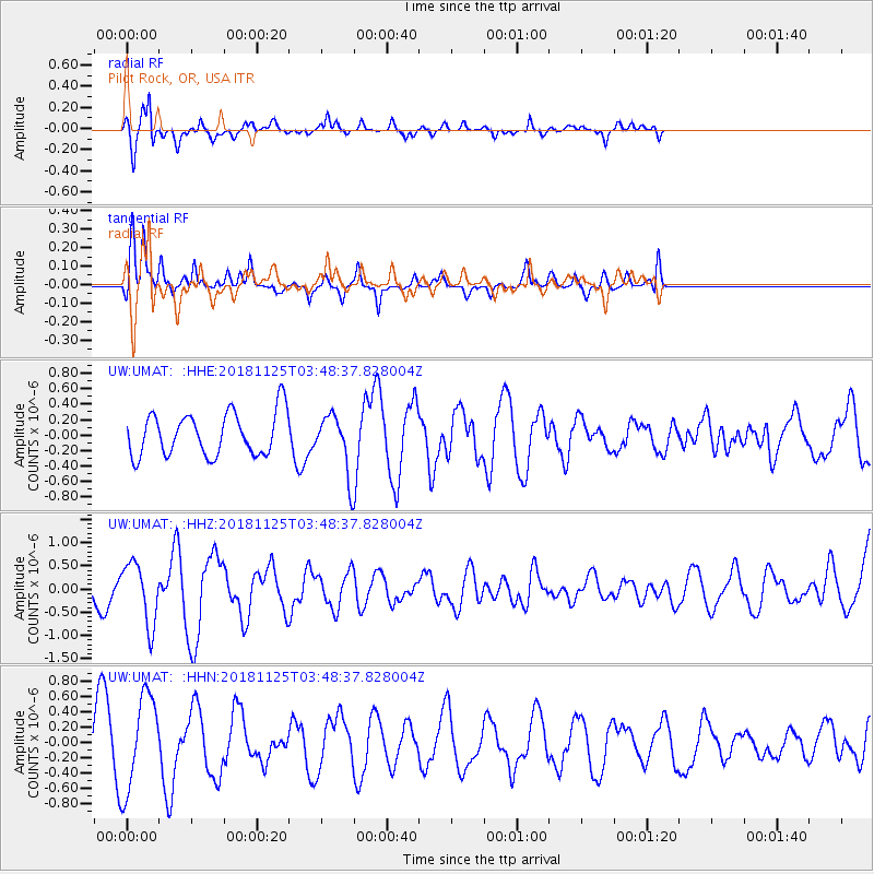
Signal To Noise
| Channel | StoN | STA | LTA |
| UW:UMAT: :HHZ:20181125T03:48:37.828004Z | 2.2162502 | 6.5851555E-7 | 2.9713053E-7 |
| UW:UMAT: :HHN:20181125T03:48:37.828004Z | 2.0252323 | 6.0988657E-7 | 3.01144E-7 |
| UW:UMAT: :HHE:20181125T03:48:37.828004Z | 1.4860646 | 4.1044922E-7 | 2.761988E-7 |
| Arrivals |
| Ps | |
| PpPs | |
| PsPs/PpSs | |


