You are here: Home > Network List > TS - TERRAscope (Southern California Seismic Network) Stations List
> Station BAR Barrett Dam, California, USA > Earthquake Result Viewer
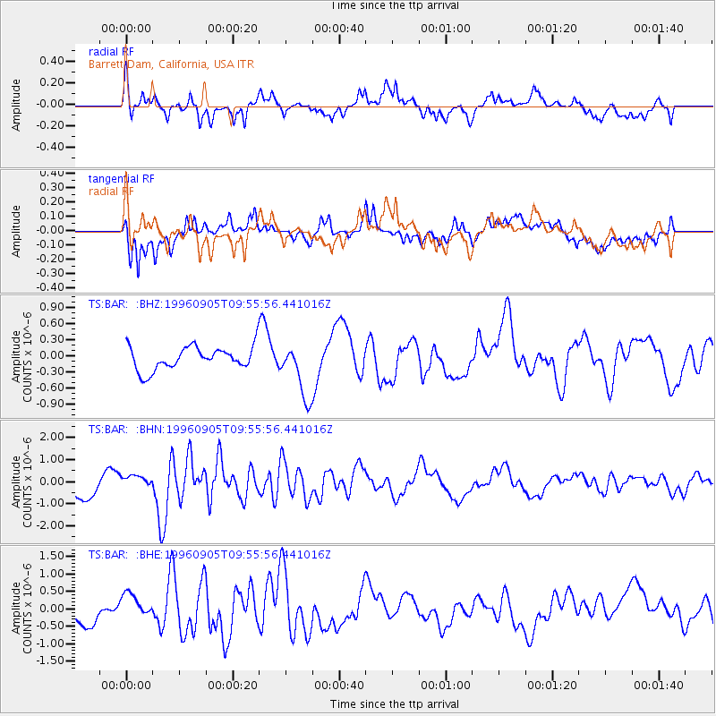
BAR Barrett Dam, California, USA - Earthquake Result Viewer
*The percent match for this event was below the threshold and hence no stack was calculated.
| Earthquake location: |
Easter Island Region |
| Earthquake latitude/longitude: |
-22.1/-113.1 |
| Earthquake time(UTC): |
1996/09/05 (249) 09:46:59 GMT |
| Earthquake Depth: |
10 km |
| Earthquake Magnitude: |
5.6 MB, 5.9 MS, 6.4 UNKNOWN |
| Earthquake Catalog/Contributor: |
WHDF/NEIC |
|
| Network: |
TS TERRAscope (Southern California Seismic Network) |
| Station: |
BAR Barrett Dam, California, USA |
| Lat/Lon: |
32.68 N/116.67 W |
| Elevation: |
548 m |
|
| Distance: |
54.5 deg |
| Az: |
356.284 deg |
| Baz: |
175.911 deg |
| Ray Param: |
$rayparam |
*The percent match for this event was below the threshold and hence was not used in the summary stack. |
|
| Radial Match: |
59.937717 % |
| Radial Bump: |
400 |
| Transverse Match: |
76.03574 % |
| Transverse Bump: |
400 |
| SOD ConfigId: |
4480 |
| Insert Time: |
2010-02-26 14:01:01.797 +0000 |
| GWidth: |
2.5 |
| Max Bumps: |
400 |
| Tol: |
0.001 |
|
Signal To Noise
| Channel | StoN | STA | LTA |
| TS:BAR: :BHN:19960905T09:55:56.441016Z | 0.7079768 | 2.9959102E-7 | 4.23165E-7 |
| TS:BAR: :BHE:19960905T09:55:56.441016Z | 0.8375851 | 4.0271175E-7 | 4.80801E-7 |
| TS:BAR: :BHZ:19960905T09:55:56.441016Z | 2.4131482 | 5.2007044E-7 | 2.1551534E-7 |
| Arrivals |
| Ps | |
| PpPs | |
| PsPs/PpSs | |


