You are here: Home > Network List > GB - Great Britain Seismograph Network Stations List
> Station CWF CHARNWOOD FOREST, ENGLAND > Earthquake Result Viewer
CWF CHARNWOOD FOREST, ENGLAND - Earthquake Result Viewer
| Earthquake location: |
Iran-Iraq Border Region |
| Earthquake latitude/longitude: |
34.3/45.7 |
| Earthquake time(UTC): |
2018/11/25 (329) 16:37:31 GMT |
| Earthquake Depth: |
10 km |
| Earthquake Magnitude: |
6.3 Mww |
| Earthquake Catalog/Contributor: |
NEIC PDE/us |
|
| Network: |
GB Great Britain Seismograph Network |
| Station: |
CWF CHARNWOOD FOREST, ENGLAND |
| Lat/Lon: |
52.74 N/1.31 W |
| Elevation: |
203 m |
|
| Distance: |
38.0 deg |
| Az: |
313.667 deg |
| Baz: |
99.988 deg |
| Ray Param: |
0.075833686 |
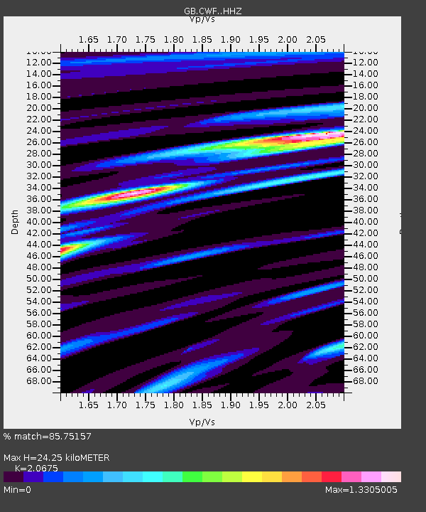
| Estimated Moho Depth: |
24.25 km |
| Estimated Crust Vp/Vs: |
2.07 |
| Assumed Crust Vp: |
6.276 km/s |
| Estimated Crust Vs: |
3.035 km/s |
| Estimated Crust Poisson's Ratio: |
0.35 |
|
| Radial Match: |
85.75157 % |
| Radial Bump: |
282 |
| Transverse Match: |
63.406136 % |
| Transverse Bump: |
400 |
| SOD ConfigId: |
13570011 |
| Insert Time: |
2019-05-01 21:39:30.568 +0000 |
| GWidth: |
2.5 |
| Max Bumps: |
400 |
| Tol: |
0.001 |
|

Signal To Noise
| Channel | StoN | STA | LTA |
| GB:CWF: :HHZ:20181125T16:44:18.300015Z | 7.59149 | 1.7510102E-6 | 2.3065436E-7 |
| GB:CWF: :HHN:20181125T16:44:18.300015Z | 1.5006944 | 3.232427E-7 | 2.1539542E-7 |
| GB:CWF: :HHE:20181125T16:44:18.300015Z | 5.244622 | 9.2443946E-7 | 1.7626427E-7 |
| Arrivals |
| Ps | 4.4 SECOND |
| PpPs | 11 SECOND |
| PsPs/PpSs | 16 SECOND |


