You are here: Home > Network List > GB - Great Britain Seismograph Network Stations List
> Station HTL HARTLAND, ENGLAND > Earthquake Result Viewer
HTL HARTLAND, ENGLAND - Earthquake Result Viewer
| Earthquake location: |
Iran-Iraq Border Region |
| Earthquake latitude/longitude: |
34.3/45.7 |
| Earthquake time(UTC): |
2018/11/25 (329) 16:37:31 GMT |
| Earthquake Depth: |
10 km |
| Earthquake Magnitude: |
6.3 Mww |
| Earthquake Catalog/Contributor: |
NEIC PDE/us |
|
| Network: |
GB Great Britain Seismograph Network |
| Station: |
HTL HARTLAND, ENGLAND |
| Lat/Lon: |
50.99 N/4.48 W |
| Elevation: |
86 m |
|
| Distance: |
39.7 deg |
| Az: |
310.495 deg |
| Baz: |
95.024 deg |
| Ray Param: |
0.074837305 |
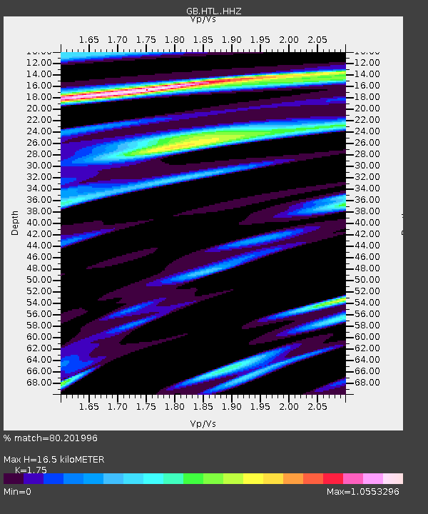
| Estimated Moho Depth: |
16.5 km |
| Estimated Crust Vp/Vs: |
1.75 |
| Assumed Crust Vp: |
6.24 km/s |
| Estimated Crust Vs: |
3.566 km/s |
| Estimated Crust Poisson's Ratio: |
0.26 |
|
| Radial Match: |
80.201996 % |
| Radial Bump: |
400 |
| Transverse Match: |
54.014366 % |
| Transverse Bump: |
400 |
| SOD ConfigId: |
13570011 |
| Insert Time: |
2019-05-01 21:39:40.404 +0000 |
| GWidth: |
2.5 |
| Max Bumps: |
400 |
| Tol: |
0.001 |
|

Signal To Noise
| Channel | StoN | STA | LTA |
| GB:HTL: :HHZ:20181125T16:44:32.760006Z | 3.973725 | 4.4386357E-7 | 1.1169961E-7 |
| GB:HTL: :HHN:20181125T16:44:32.760006Z | 1.2975485 | 1.4005693E-7 | 1.0793964E-7 |
| GB:HTL: :HHE:20181125T16:44:32.760006Z | 2.9182358 | 2.2978911E-7 | 7.8742474E-8 |
| Arrivals |
| Ps | 2.1 SECOND |
| PpPs | 6.8 SECOND |
| PsPs/PpSs | 8.9 SECOND |


