You are here: Home > Network List > TA - USArray Transportable Network (new EarthScope stations) Stations List
> Station K17A Gardner Place, Afton, WY, USA > Earthquake Result Viewer
K17A Gardner Place, Afton, WY, USA - Earthquake Result Viewer
| Earthquake location: |
Off East Coast Of Honshu, Japan |
| Earthquake latitude/longitude: |
37.6/142.2 |
| Earthquake time(UTC): |
2008/07/19 (201) 02:39:28 GMT |
| Earthquake Depth: |
22 km |
| Earthquake Magnitude: |
6.2 MB, 7.0 MS, 7.0 MW, 6.9 MW |
| Earthquake Catalog/Contributor: |
WHDF/NEIC |
|
| Network: |
TA USArray Transportable Network (new EarthScope stations) |
| Station: |
K17A Gardner Place, Afton, WY, USA |
| Lat/Lon: |
42.75 N/110.92 W |
| Elevation: |
1922 m |
|
| Distance: |
76.1 deg |
| Az: |
46.572 deg |
| Baz: |
308.407 deg |
| Ray Param: |
0.051214494 |
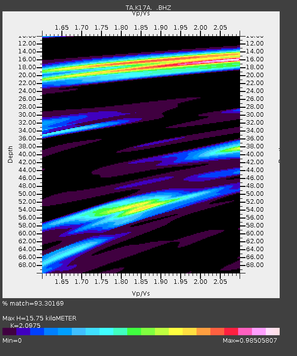
| Estimated Moho Depth: |
15.75 km |
| Estimated Crust Vp/Vs: |
2.10 |
| Assumed Crust Vp: |
6.207 km/s |
| Estimated Crust Vs: |
2.959 km/s |
| Estimated Crust Poisson's Ratio: |
0.35 |
|
| Radial Match: |
93.30169 % |
| Radial Bump: |
400 |
| Transverse Match: |
79.927734 % |
| Transverse Bump: |
400 |
| SOD ConfigId: |
2504 |
| Insert Time: |
2010-03-06 18:13:05.815 +0000 |
| GWidth: |
2.5 |
| Max Bumps: |
400 |
| Tol: |
0.001 |
|
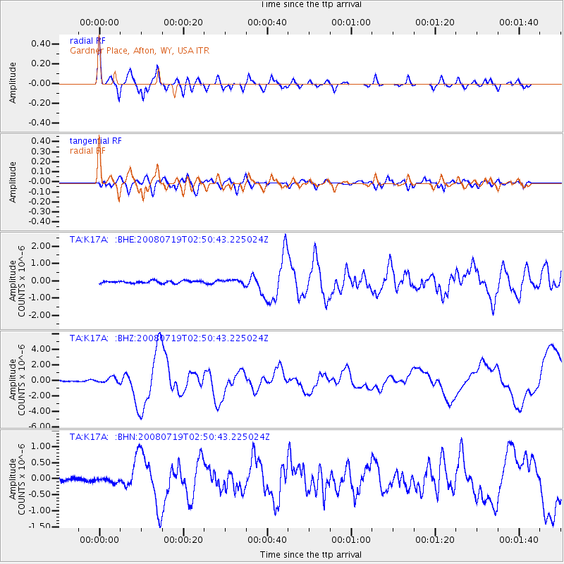
Signal To Noise
| Channel | StoN | STA | LTA |
| TA:K17A: :BHZ:20080719T02:50:43.225024Z | 5.4899864 | 3.5837124E-7 | 6.5277256E-8 |
| TA:K17A: :BHN:20080719T02:50:43.225024Z | 0.8807867 | 7.070586E-8 | 8.02758E-8 |
| TA:K17A: :BHE:20080719T02:50:43.225024Z | 1.72801 | 1.1661356E-7 | 6.748431E-8 |
| Arrivals |
| Ps | 2.9 SECOND |
| PpPs | 7.7 SECOND |
| PsPs/PpSs | 11 SECOND |


