You are here: Home > Network List > TA - USArray Transportable Network (new EarthScope stations) Stations List
> Station D25K Kavik River, AK, USA > Earthquake Result Viewer
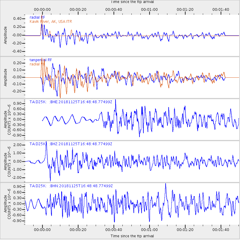
D25K Kavik River, AK, USA - Earthquake Result Viewer
*The percent match for this event was below the threshold and hence no stack was calculated.
| Earthquake location: |
Iran-Iraq Border Region |
| Earthquake latitude/longitude: |
34.3/45.7 |
| Earthquake time(UTC): |
2018/11/25 (329) 16:37:31 GMT |
| Earthquake Depth: |
10 km |
| Earthquake Magnitude: |
6.3 Mww |
| Earthquake Catalog/Contributor: |
NEIC PDE/us |
|
| Network: |
TA USArray Transportable Network (new EarthScope stations) |
| Station: |
D25K Kavik River, AK, USA |
| Lat/Lon: |
69.32 N/146.38 W |
| Elevation: |
770 m |
|
| Distance: |
76.3 deg |
| Az: |
4.401 deg |
| Baz: |
349.698 deg |
| Ray Param: |
$rayparam |
*The percent match for this event was below the threshold and hence was not used in the summary stack. |
|
| Radial Match: |
71.466286 % |
| Radial Bump: |
400 |
| Transverse Match: |
73.36375 % |
| Transverse Bump: |
400 |
| SOD ConfigId: |
13570011 |
| Insert Time: |
2019-05-01 21:42:59.298 +0000 |
| GWidth: |
2.5 |
| Max Bumps: |
400 |
| Tol: |
0.001 |
|
Signal To Noise
| Channel | StoN | STA | LTA |
| TA:D25K: :BHZ:20181125T16:48:48.77499Z | 10.498105 | 1.026621E-6 | 9.779107E-8 |
| TA:D25K: :BHN:20181125T16:48:48.77499Z | 1.3888527 | 2.5292206E-7 | 1.8210864E-7 |
| TA:D25K: :BHE:20181125T16:48:48.77499Z | 1.4141903 | 2.1561927E-7 | 1.5246836E-7 |
| Arrivals |
| Ps | |
| PpPs | |
| PsPs/PpSs | |


