You are here: Home > Network List > TA - USArray Transportable Network (new EarthScope stations) Stations List
> Station K17A Gardner Place, Afton, WY, USA > Earthquake Result Viewer
K17A Gardner Place, Afton, WY, USA - Earthquake Result Viewer
| Earthquake location: |
Kuril Islands |
| Earthquake latitude/longitude: |
46.0/151.5 |
| Earthquake time(UTC): |
2009/04/07 (097) 04:23:33 GMT |
| Earthquake Depth: |
31 km |
| Earthquake Magnitude: |
6.5 MB, 6.8 MS, 6.9 MW, 6.9 MW |
| Earthquake Catalog/Contributor: |
WHDF/NEIC |
|
| Network: |
TA USArray Transportable Network (new EarthScope stations) |
| Station: |
K17A Gardner Place, Afton, WY, USA |
| Lat/Lon: |
42.75 N/110.92 W |
| Elevation: |
1922 m |
|
| Distance: |
65.3 deg |
| Az: |
53.5 deg |
| Baz: |
310.53 deg |
| Ray Param: |
0.05832416 |
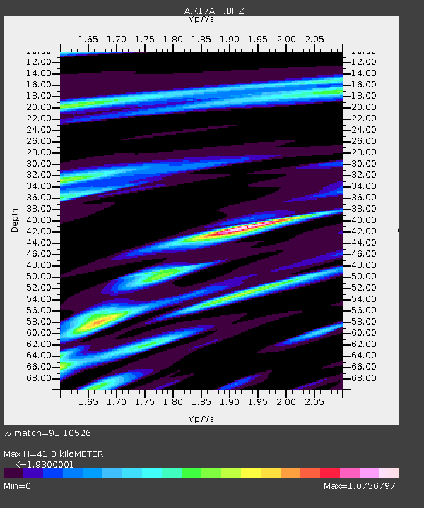
| Estimated Moho Depth: |
41.0 km |
| Estimated Crust Vp/Vs: |
1.93 |
| Assumed Crust Vp: |
6.207 km/s |
| Estimated Crust Vs: |
3.216 km/s |
| Estimated Crust Poisson's Ratio: |
0.32 |
|
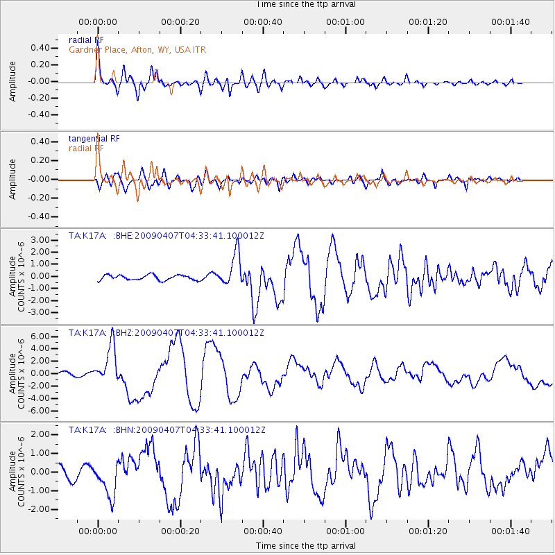
| Radial Match: |
91.10526 % |
| Radial Bump: |
400 |
| Transverse Match: |
75.68391 % |
| Transverse Bump: |
400 |
| SOD ConfigId: |
2760 |
| Insert Time: |
2010-03-06 18:13:29.869 +0000 |
| GWidth: |
2.5 |
| Max Bumps: |
400 |
| Tol: |
0.001 |
|
Signal To Noise
| Channel | StoN | STA | LTA |
| TA:K17A: :BHZ:20090407T04:33:41.100012Z | 10.84982 | 3.2256462E-6 | 2.9729952E-7 |
| TA:K17A: :BHN:20090407T04:33:41.100012Z | 2.723195 | 9.707637E-7 | 3.564797E-7 |
| TA:K17A: :BHE:20090407T04:33:41.100012Z | 6.773611 | 1.4166282E-6 | 2.0913929E-7 |
| Arrivals |
| Ps | 6.4 SECOND |
| PpPs | 19 SECOND |
| PsPs/PpSs | 25 SECOND |


