You are here: Home > Network List > TA - USArray Transportable Network (new EarthScope stations) Stations List
> Station K17A Gardner Place, Afton, WY, USA > Earthquake Result Viewer
K17A Gardner Place, Afton, WY, USA - Earthquake Result Viewer
| Earthquake location: |
Kuril Islands |
| Earthquake latitude/longitude: |
46.0/151.4 |
| Earthquake time(UTC): |
2009/04/18 (108) 19:17:58 GMT |
| Earthquake Depth: |
35 km |
| Earthquake Magnitude: |
6.3 MB, 6.3 MS, 6.6 MW, 6.4 MW |
| Earthquake Catalog/Contributor: |
WHDF/NEIC |
|
| Network: |
TA USArray Transportable Network (new EarthScope stations) |
| Station: |
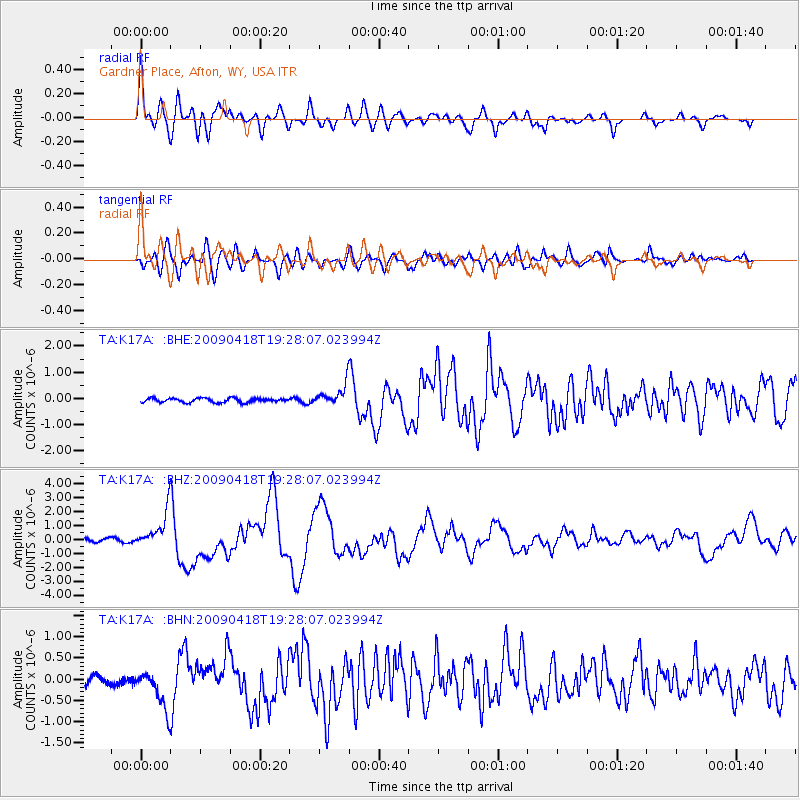
K17A Gardner Place, Afton, WY, USA |
| Lat/Lon: |
42.75 N/110.92 W |
| Elevation: |
1922 m |
|
| Distance: |
65.4 deg |
| Az: |
53.424 deg |
| Baz: |
310.555 deg |
| Ray Param: |
0.058256667 |
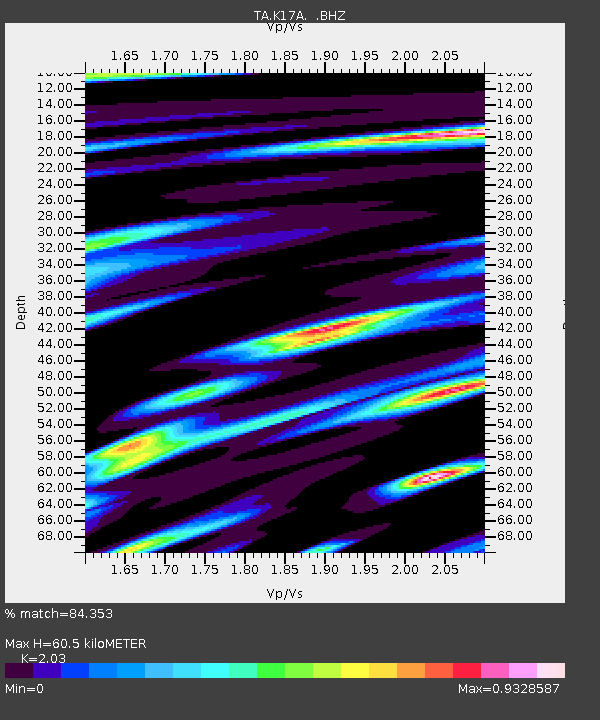
| Estimated Moho Depth: |
60.5 km |
| Estimated Crust Vp/Vs: |
2.03 |
| Assumed Crust Vp: |
6.207 km/s |
| Estimated Crust Vs: |
3.058 km/s |
| Estimated Crust Poisson's Ratio: |
0.34 |
|
| Radial Match: |
84.353 % |
| Radial Bump: |
400 |
| Transverse Match: |
78.670845 % |
| Transverse Bump: |
400 |
| SOD ConfigId: |
2760 |
| Insert Time: |
2010-03-06 18:13:33.098 +0000 |
| GWidth: |
2.5 |
| Max Bumps: |
400 |
| Tol: |
0.001 |
|
Signal To Noise
| Channel | StoN | STA | LTA |
| TA:K17A: :BHZ:20090418T19:28:07.023994Z | 10.986493 | 1.285761E-6 | 1.1703106E-7 |
| TA:K17A: :BHN:20090418T19:28:07.023994Z | 3.7285047 | 4.560319E-7 | 1.2230959E-7 |
| TA:K17A: :BHE:20090418T19:28:07.023994Z | 5.1113224 | 4.0193595E-7 | 7.863639E-8 |
| Arrivals |
| Ps | 10 SECOND |
| PpPs | 29 SECOND |
| PsPs/PpSs | 39 SECOND |


