You are here: Home > Network List > TA - USArray Transportable Network (new EarthScope stations) Stations List
> Station G23K Bananza Creek, AK, USA > Earthquake Result Viewer
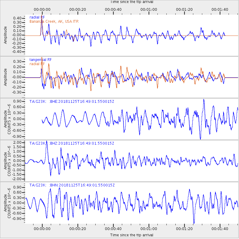
G23K Bananza Creek, AK, USA - Earthquake Result Viewer
*The percent match for this event was below the threshold and hence no stack was calculated.
| Earthquake location: |
Iran-Iraq Border Region |
| Earthquake latitude/longitude: |
34.3/45.7 |
| Earthquake time(UTC): |
2018/11/25 (329) 16:37:31 GMT |
| Earthquake Depth: |
10 km |
| Earthquake Magnitude: |
6.3 Mww |
| Earthquake Catalog/Contributor: |
NEIC PDE/us |
|
| Network: |
TA USArray Transportable Network (new EarthScope stations) |
| Station: |
G23K Bananza Creek, AK, USA |
| Lat/Lon: |
66.71 N/150.02 W |
| Elevation: |
746 m |
|
| Distance: |
78.6 deg |
| Az: |
6.327 deg |
| Baz: |
346.736 deg |
| Ray Param: |
$rayparam |
*The percent match for this event was below the threshold and hence was not used in the summary stack. |
|
| Radial Match: |
75.345085 % |
| Radial Bump: |
359 |
| Transverse Match: |
57.124653 % |
| Transverse Bump: |
400 |
| SOD ConfigId: |
13570011 |
| Insert Time: |
2019-05-01 21:43:28.339 +0000 |
| GWidth: |
2.5 |
| Max Bumps: |
400 |
| Tol: |
0.001 |
|
Signal To Noise
| Channel | StoN | STA | LTA |
| TA:G23K: :BHZ:20181125T16:49:01.550015Z | 5.450705 | 8.960665E-7 | 1.6439462E-7 |
| TA:G23K: :BHN:20181125T16:49:01.550015Z | 2.6888251 | 4.6347995E-7 | 1.7237267E-7 |
| TA:G23K: :BHE:20181125T16:49:01.550015Z | 1.1981105 | 2.611816E-7 | 2.1799458E-7 |
| Arrivals |
| Ps | |
| PpPs | |
| PsPs/PpSs | |


