You are here: Home > Network List > TA - USArray Transportable Network (new EarthScope stations) Stations List
> Station K17A Gardner Place, Afton, WY, USA > Earthquake Result Viewer
K17A Gardner Place, Afton, WY, USA - Earthquake Result Viewer
| Earthquake location: |
Loyalty Islands |
| Earthquake latitude/longitude: |
-20.1/168.9 |
| Earthquake time(UTC): |
2008/04/09 (100) 12:46:12 GMT |
| Earthquake Depth: |
33 km |
| Earthquake Magnitude: |
6.3 MB, 7.3 MS, 7.3 MW, 7.3 MW |
| Earthquake Catalog/Contributor: |
WHDF/NEIC |
|
| Network: |
TA USArray Transportable Network (new EarthScope stations) |
| Station: |
K17A Gardner Place, Afton, WY, USA |
| Lat/Lon: |
42.75 N/110.92 W |
| Elevation: |
1922 m |
|
| Distance: |
96.5 deg |
| Az: |
46.925 deg |
| Baz: |
248.78 deg |
| Ray Param: |
0.04048884 |
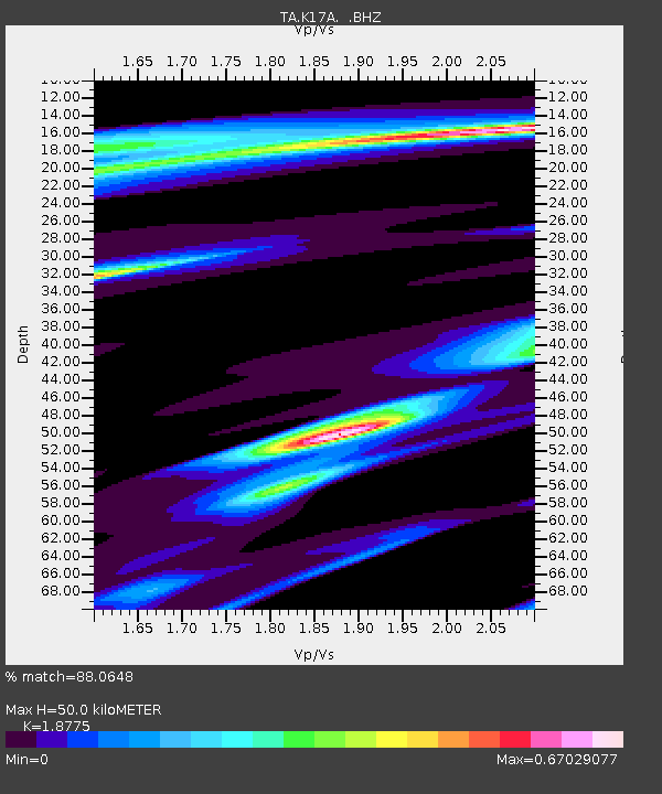
| Estimated Moho Depth: |
50.0 km |
| Estimated Crust Vp/Vs: |
1.88 |
| Assumed Crust Vp: |
6.207 km/s |
| Estimated Crust Vs: |
3.306 km/s |
| Estimated Crust Poisson's Ratio: |
0.30 |
|
| Radial Match: |
88.0648 % |
| Radial Bump: |
210 |
| Transverse Match: |
87.94143 % |
| Transverse Bump: |
213 |
| SOD ConfigId: |
2504 |
| Insert Time: |
2010-03-06 18:13:40.036 +0000 |
| GWidth: |
2.5 |
| Max Bumps: |
400 |
| Tol: |
0.001 |
|
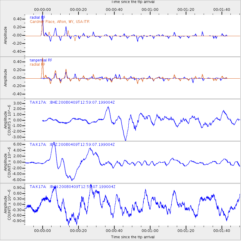
Signal To Noise
| Channel | StoN | STA | LTA |
| TA:K17A: :BHZ:20080409T12:59:07.199004Z | 6.0606914 | 1.0366231E-6 | 1.7104041E-7 |
| TA:K17A: :BHN:20080409T12:59:07.199004Z | 1.7669073 | 3.0717302E-7 | 1.7384784E-7 |
| TA:K17A: :BHE:20080409T12:59:07.199004Z | 1.0544066 | 2.7760007E-7 | 2.632761E-7 |
| Arrivals |
| Ps | 7.2 SECOND |
| PpPs | 23 SECOND |
| PsPs/PpSs | 30 SECOND |


