You are here: Home > Network List > TA - USArray Transportable Network (new EarthScope stations) Stations List
> Station K17A Gardner Place, Afton, WY, USA > Earthquake Result Viewer
K17A Gardner Place, Afton, WY, USA - Earthquake Result Viewer
| Earthquake location: |
Near Coast Of Guatemala |
| Earthquake latitude/longitude: |
13.6/-90.6 |
| Earthquake time(UTC): |
2008/04/15 (106) 03:03:04 GMT |
| Earthquake Depth: |
33 km |
| Earthquake Magnitude: |
5.6 MB, 5.8 MS, 6.1 MW, 6.1 MW |
| Earthquake Catalog/Contributor: |
WHDF/NEIC |
|
| Network: |
TA USArray Transportable Network (new EarthScope stations) |
| Station: |
K17A Gardner Place, Afton, WY, USA |
| Lat/Lon: |
42.75 N/110.92 W |
| Elevation: |
1922 m |
|
| Distance: |
34.0 deg |
| Az: |
332.754 deg |
| Baz: |
142.813 deg |
| Ray Param: |
0.07791003 |
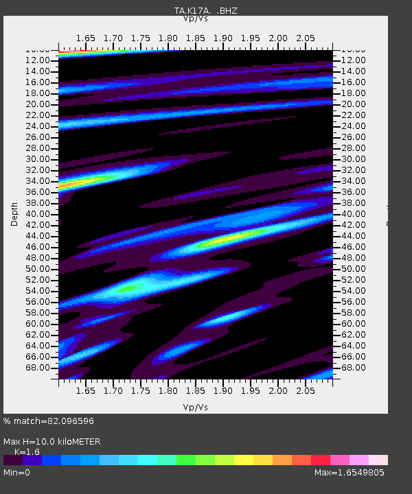
| Estimated Moho Depth: |
10.0 km |
| Estimated Crust Vp/Vs: |
1.60 |
| Assumed Crust Vp: |
6.207 km/s |
| Estimated Crust Vs: |
3.879 km/s |
| Estimated Crust Poisson's Ratio: |
0.18 |
|
| Radial Match: |
82.096596 % |
| Radial Bump: |
400 |
| Transverse Match: |
63.118603 % |
| Transverse Bump: |
400 |
| SOD ConfigId: |
2504 |
| Insert Time: |
2010-03-06 18:13:42.015 +0000 |
| GWidth: |
2.5 |
| Max Bumps: |
400 |
| Tol: |
0.001 |
|
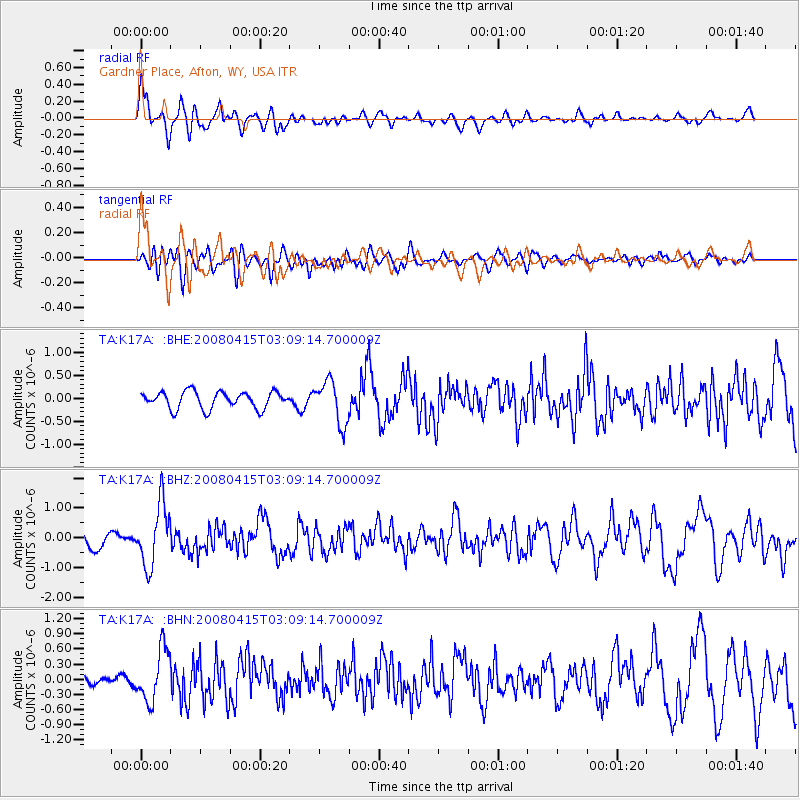
Signal To Noise
| Channel | StoN | STA | LTA |
| TA:K17A: :BHZ:20080415T03:09:14.700009Z | 3.633244 | 1.0313877E-6 | 2.8387512E-7 |
| TA:K17A: :BHN:20080415T03:09:14.700009Z | 3.7586064 | 5.162205E-7 | 1.3734358E-7 |
| TA:K17A: :BHE:20080415T03:09:14.700009Z | 2.5570407 | 4.6943615E-7 | 1.8358573E-7 |
| Arrivals |
| Ps | 1.0 SECOND |
| PpPs | 3.9 SECOND |
| PsPs/PpSs | 4.9 SECOND |


