You are here: Home > Network List > TA - USArray Transportable Network (new EarthScope stations) Stations List
> Station K17A Gardner Place, Afton, WY, USA > Earthquake Result Viewer
K17A Gardner Place, Afton, WY, USA - Earthquake Result Viewer
| Earthquake location: |
Central Mid-Atlantic Ridge |
| Earthquake latitude/longitude: |
7.3/-34.9 |
| Earthquake time(UTC): |
2008/05/23 (144) 19:35:34 GMT |
| Earthquake Depth: |
9.0 km |
| Earthquake Magnitude: |
6.0 MB, 6.4 MS, 6.5 MW, 6.5 MW |
| Earthquake Catalog/Contributor: |
WHDF/NEIC |
|
| Network: |
TA USArray Transportable Network (new EarthScope stations) |
| Station: |
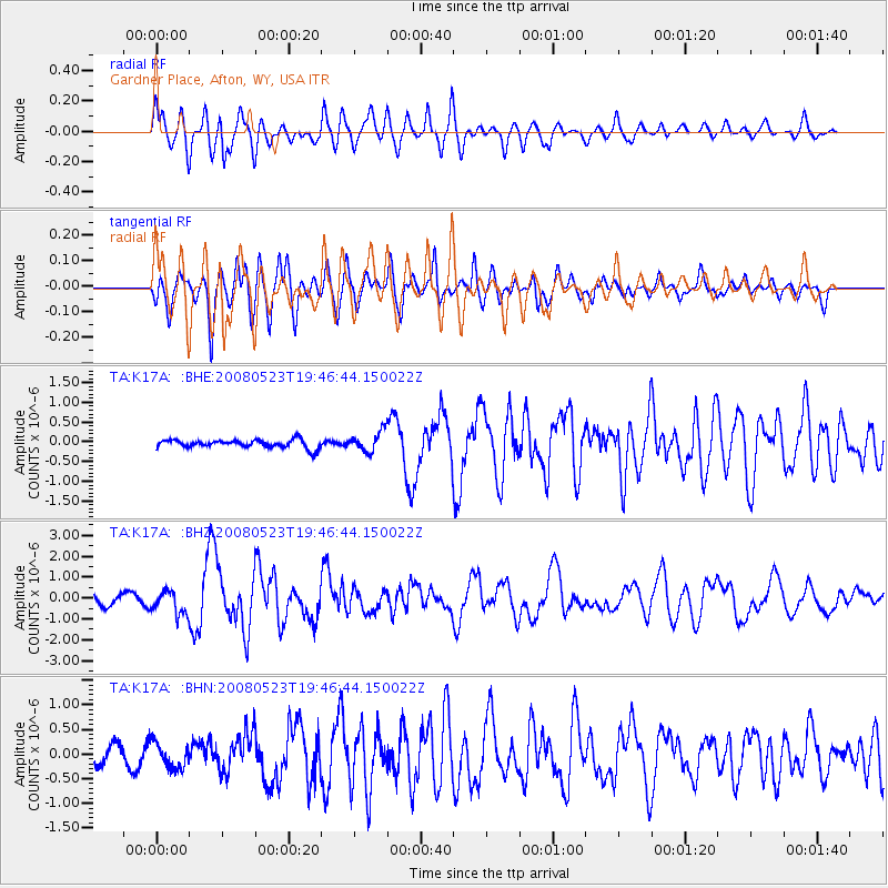
K17A Gardner Place, Afton, WY, USA |
| Lat/Lon: |
42.75 N/110.92 W |
| Elevation: |
1922 m |
|
| Distance: |
74.8 deg |
| Az: |
312.213 deg |
| Baz: |
94.094 deg |
| Ray Param: |
0.052084662 |
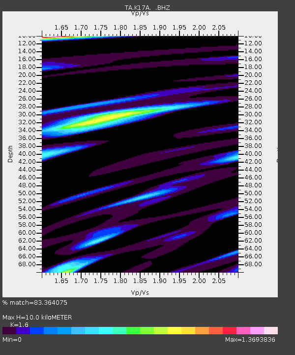
| Estimated Moho Depth: |
10.0 km |
| Estimated Crust Vp/Vs: |
1.60 |
| Assumed Crust Vp: |
6.207 km/s |
| Estimated Crust Vs: |
3.879 km/s |
| Estimated Crust Poisson's Ratio: |
0.18 |
|
| Radial Match: |
83.364075 % |
| Radial Bump: |
400 |
| Transverse Match: |
76.01261 % |
| Transverse Bump: |
400 |
| SOD ConfigId: |
2504 |
| Insert Time: |
2010-03-06 18:13:50.763 +0000 |
| GWidth: |
2.5 |
| Max Bumps: |
400 |
| Tol: |
0.001 |
|
Signal To Noise
| Channel | StoN | STA | LTA |
| TA:K17A: :BHZ:20080523T19:46:44.150022Z | 1.6539567 | 5.599076E-7 | 3.3852615E-7 |
| TA:K17A: :BHN:20080523T19:46:44.150022Z | 1.2021967 | 2.5871554E-7 | 2.1520233E-7 |
| TA:K17A: :BHE:20080523T19:46:44.150022Z | 2.5243483 | 2.601396E-7 | 1.0305218E-7 |
| Arrivals |
| Ps | 1.0 SECOND |
| PpPs | 4.0 SECOND |
| PsPs/PpSs | 5.0 SECOND |


