You are here: Home > Network List > TA - USArray Transportable Network (new EarthScope stations) Stations List
> Station K17A Gardner Place, Afton, WY, USA > Earthquake Result Viewer
K17A Gardner Place, Afton, WY, USA - Earthquake Result Viewer
| Earthquake location: |
Fiji Islands Region |
| Earthquake latitude/longitude: |
-17.7/-179.7 |
| Earthquake time(UTC): |
2008/06/15 (167) 01:13:11 GMT |
| Earthquake Depth: |
611 km |
| Earthquake Magnitude: |
5.5 MB, 5.9 MW, 5.9 MW |
| Earthquake Catalog/Contributor: |
WHDF/NEIC |
|
| Network: |
TA USArray Transportable Network (new EarthScope stations) |
| Station: |
K17A Gardner Place, Afton, WY, USA |
| Lat/Lon: |
42.75 N/110.92 W |
| Elevation: |
1922 m |
|
| Distance: |
87.2 deg |
| Az: |
43.442 deg |
| Baz: |
242.837 deg |
| Ray Param: |
0.04173906 |
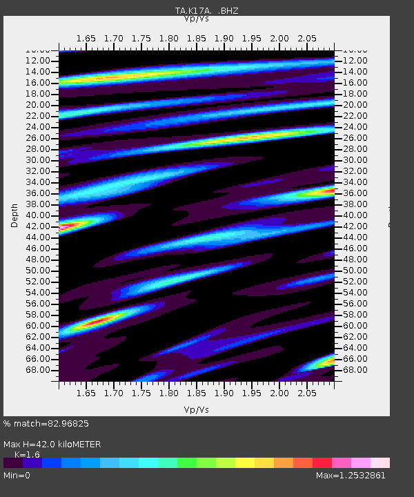
| Estimated Moho Depth: |
42.0 km |
| Estimated Crust Vp/Vs: |
1.60 |
| Assumed Crust Vp: |
6.207 km/s |
| Estimated Crust Vs: |
3.879 km/s |
| Estimated Crust Poisson's Ratio: |
0.18 |
|
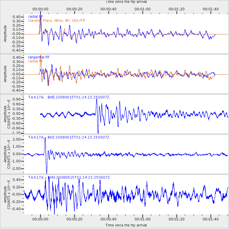
| Radial Match: |
82.96825 % |
| Radial Bump: |
400 |
| Transverse Match: |
76.126434 % |
| Transverse Bump: |
358 |
| SOD ConfigId: |
2504 |
| Insert Time: |
2010-03-06 18:13:53.382 +0000 |
| GWidth: |
2.5 |
| Max Bumps: |
400 |
| Tol: |
0.001 |
|
Signal To Noise
| Channel | StoN | STA | LTA |
| TA:K17A: :BHZ:20080615T01:24:23.250007Z | 14.289784 | 1.052441E-6 | 7.3649886E-8 |
| TA:K17A: :BHN:20080615T01:24:23.250007Z | 2.5843868 | 1.7607725E-7 | 6.813116E-8 |
| TA:K17A: :BHE:20080615T01:24:23.250007Z | 5.261382 | 4.3033057E-7 | 8.1790404E-8 |
| Arrivals |
| Ps | 4.1 SECOND |
| PpPs | 17 SECOND |
| PsPs/PpSs | 21 SECOND |


