You are here: Home > Network List > TA - USArray Transportable Network (new EarthScope stations) Stations List
> Station O19K Port Alsworth, AK, USA > Earthquake Result Viewer
O19K Port Alsworth, AK, USA - Earthquake Result Viewer
| Earthquake location: |
Iran-Iraq Border Region |
| Earthquake latitude/longitude: |
34.3/45.7 |
| Earthquake time(UTC): |
2018/11/25 (329) 16:37:31 GMT |
| Earthquake Depth: |
10 km |
| Earthquake Magnitude: |
6.3 Mww |
| Earthquake Catalog/Contributor: |
NEIC PDE/us |
|
| Network: |
TA USArray Transportable Network (new EarthScope stations) |
| Station: |
O19K Port Alsworth, AK, USA |
| Lat/Lon: |
60.20 N/154.32 W |
| Elevation: |
96 m |
|
| Distance: |
84.4 deg |
| Az: |
9.914 deg |
| Baz: |
343.423 deg |
| Ray Param: |
0.045508295 |
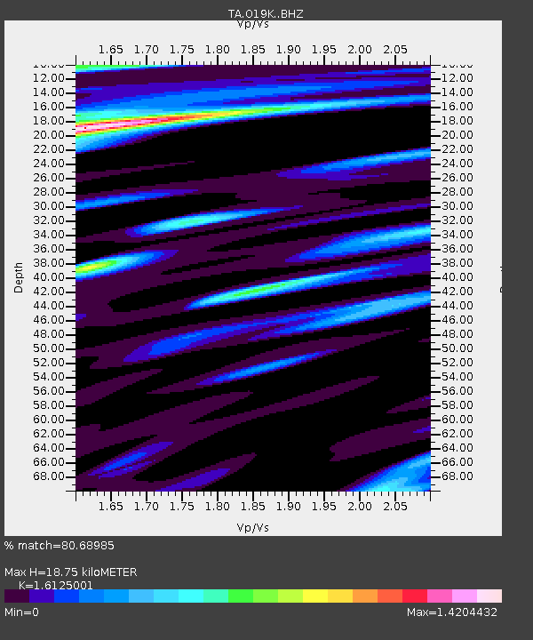
| Estimated Moho Depth: |
18.75 km |
| Estimated Crust Vp/Vs: |
1.61 |
| Assumed Crust Vp: |
6.566 km/s |
| Estimated Crust Vs: |
4.072 km/s |
| Estimated Crust Poisson's Ratio: |
0.19 |
|
| Radial Match: |
80.68985 % |
| Radial Bump: |
400 |
| Transverse Match: |
62.068085 % |
| Transverse Bump: |
400 |
| SOD ConfigId: |
13570011 |
| Insert Time: |
2019-05-01 21:44:20.976 +0000 |
| GWidth: |
2.5 |
| Max Bumps: |
400 |
| Tol: |
0.001 |
|

Signal To Noise
| Channel | StoN | STA | LTA |
| TA:O19K: :BHZ:20181125T16:49:32.250027Z | 2.4382255 | 1.3350167E-6 | 5.4753616E-7 |
| TA:O19K: :BHN:20181125T16:49:32.250027Z | 0.5376901 | 2.1052101E-7 | 3.9152854E-7 |
| TA:O19K: :BHE:20181125T16:49:32.250027Z | 1.1139563 | 4.6730187E-7 | 4.1949747E-7 |
| Arrivals |
| Ps | 1.8 SECOND |
| PpPs | 7.2 SECOND |
| PsPs/PpSs | 9.0 SECOND |


