You are here: Home > Network List > TA - USArray Transportable Network (new EarthScope stations) Stations List
> Station R31K City Hall, Gustavus, AK, USA > Earthquake Result Viewer
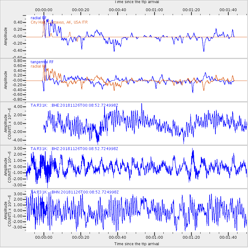
R31K City Hall, Gustavus, AK, USA - Earthquake Result Viewer
*The percent match for this event was below the threshold and hence no stack was calculated.
| Earthquake location: |
Taiwan Region |
| Earthquake latitude/longitude: |
23.4/118.6 |
| Earthquake time(UTC): |
2018/11/25 (329) 23:57:25 GMT |
| Earthquake Depth: |
13 km |
| Earthquake Magnitude: |
5.7 Mww |
| Earthquake Catalog/Contributor: |
NEIC PDE/us |
|
| Network: |
TA USArray Transportable Network (new EarthScope stations) |
| Station: |
R31K City Hall, Gustavus, AK, USA |
| Lat/Lon: |
58.41 N/135.74 W |
| Elevation: |
15 m |
|
| Distance: |
78.2 deg |
| Az: |
31.188 deg |
| Baz: |
295.332 deg |
| Ray Param: |
$rayparam |
*The percent match for this event was below the threshold and hence was not used in the summary stack. |
|
| Radial Match: |
16.937498 % |
| Radial Bump: |
400 |
| Transverse Match: |
53.61921 % |
| Transverse Bump: |
400 |
| SOD ConfigId: |
13570011 |
| Insert Time: |
2019-05-01 21:58:43.019 +0000 |
| GWidth: |
2.5 |
| Max Bumps: |
400 |
| Tol: |
0.001 |
|
Signal To Noise
| Channel | StoN | STA | LTA |
| TA:R31K: :BHZ:20181126T00:08:52.724998Z | 1.2454484 | 1.2696736E-6 | 1.019451E-6 |
| TA:R31K: :BHN:20181126T00:08:52.724998Z | 1.2475886 | 1.62092E-6 | 1.2992423E-6 |
| TA:R31K: :BHE:20181126T00:08:52.724998Z | 1.4244641 | 2.030617E-6 | 1.4255304E-6 |
| Arrivals |
| Ps | |
| PpPs | |
| PsPs/PpSs | |


