You are here: Home > Network List > PF - Volcanologic Network of Piton de Fournaise-OVPF Stations List
> Station HIM cratere Himiltrude > Earthquake Result Viewer
HIM cratere Himiltrude - Earthquake Result Viewer
*The percent match for this event was below the threshold and hence no stack was calculated.
| Earthquake location: |
Flores Sea |
| Earthquake latitude/longitude: |
-7.3/122.5 |
| Earthquake time(UTC): |
2016/08/23 (236) 19:39:44 GMT |
| Earthquake Depth: |
528 km |
| Earthquake Magnitude: |
6.0 MB |
| Earthquake Catalog/Contributor: |
NEIC PDE/NEIC COMCAT |
|
| Network: |
PF Volcanologic Network of Piton de Fournaise-OVPF |
| Station: |
HIM cratere Himiltrude |
| Lat/Lon: |
21.21 S/55.72 E |
| Elevation: |
1958 m |
|
| Distance: |
65.7 deg |
| Az: |
250.093 deg |
| Baz: |
88.525 deg |
| Ray Param: |
$rayparam |
*The percent match for this event was below the threshold and hence was not used in the summary stack. |
|
| Radial Match: |
46.70461 % |
| Radial Bump: |
400 |
| Transverse Match: |
57.78963 % |
| Transverse Bump: |
400 |
| SOD ConfigId: |
1634031 |
| Insert Time: |
2016-09-06 19:43:40.331 +0000 |
| GWidth: |
2.5 |
| Max Bumps: |
400 |
| Tol: |
0.001 |
|
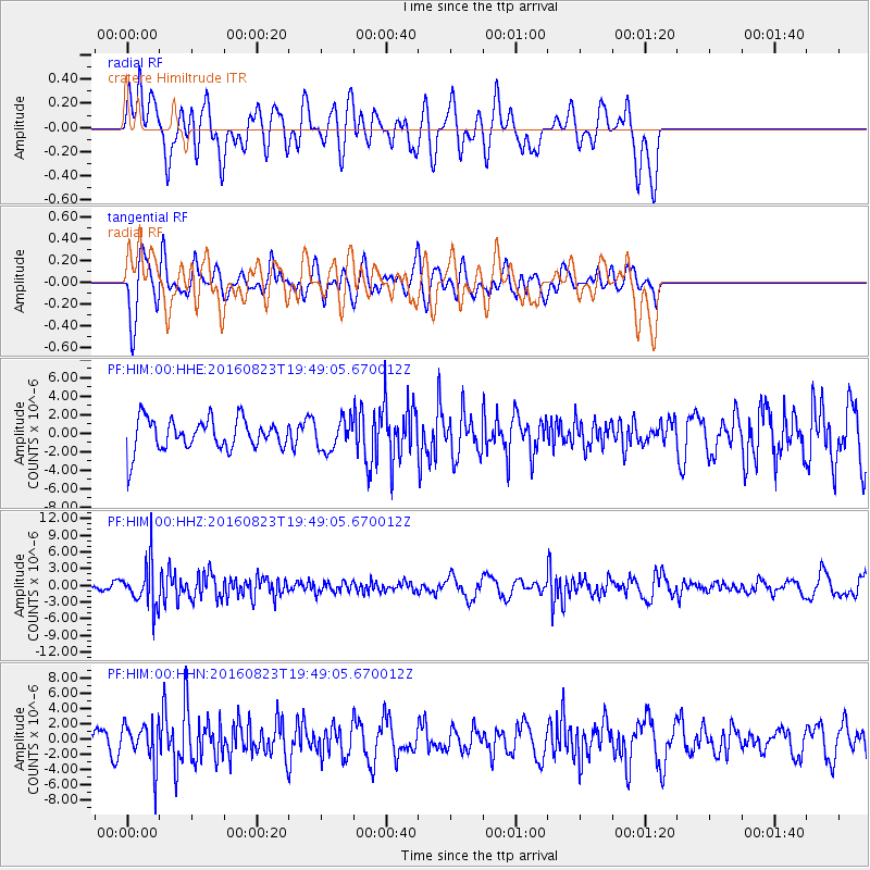
Signal To Noise
| Channel | StoN | STA | LTA |
| PF:HIM:00:HHZ:20160823T19:49:05.670012Z | 3.7900903 | 3.908907E-6 | 1.0313493E-6 |
| PF:HIM:00:HHN:20160823T19:49:05.670012Z | 1.8080064 | 2.7760555E-6 | 1.5354234E-6 |
| PF:HIM:00:HHE:20160823T19:49:05.670012Z | 0.94543076 | 1.6344895E-6 | 1.7288305E-6 |
| Arrivals |
| Ps | |
| PpPs | |
| PsPs/PpSs | |


