You are here: Home > Network List > TA - USArray Transportable Network (new EarthScope stations) Stations List
> Station R21A Cimarron, CO, USA > Earthquake Result Viewer
R21A Cimarron, CO, USA - Earthquake Result Viewer
| Earthquake location: |
Peru-Brazil Border Region |
| Earthquake latitude/longitude: |
-7.6/-74.4 |
| Earthquake time(UTC): |
2008/08/26 (239) 21:00:36 GMT |
| Earthquake Depth: |
154 km |
| Earthquake Magnitude: |
6.0 MB, 6.4 MW, 6.4 MW |
| Earthquake Catalog/Contributor: |
WHDF/NEIC |
|
| Network: |
TA USArray Transportable Network (new EarthScope stations) |
| Station: |
R21A Cimarron, CO, USA |
| Lat/Lon: |
38.37 N/107.55 W |
| Elevation: |
2260 m |
|
| Distance: |
55.2 deg |
| Az: |
328.419 deg |
| Baz: |
138.669 deg |
| Ray Param: |
0.064436235 |
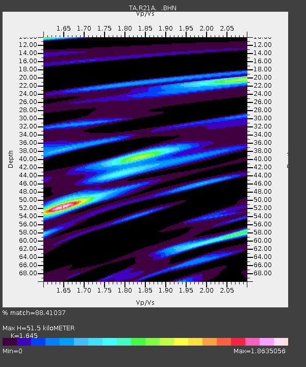
| Estimated Moho Depth: |
51.5 km |
| Estimated Crust Vp/Vs: |
1.64 |
| Assumed Crust Vp: |
6.306 km/s |
| Estimated Crust Vs: |
3.833 km/s |
| Estimated Crust Poisson's Ratio: |
0.21 |
|
| Radial Match: |
88.41037 % |
| Radial Bump: |
400 |
| Transverse Match: |
86.11364 % |
| Transverse Bump: |
400 |
| SOD ConfigId: |
2504 |
| Insert Time: |
2010-03-06 18:15:33.051 +0000 |
| GWidth: |
2.5 |
| Max Bumps: |
400 |
| Tol: |
0.001 |
|
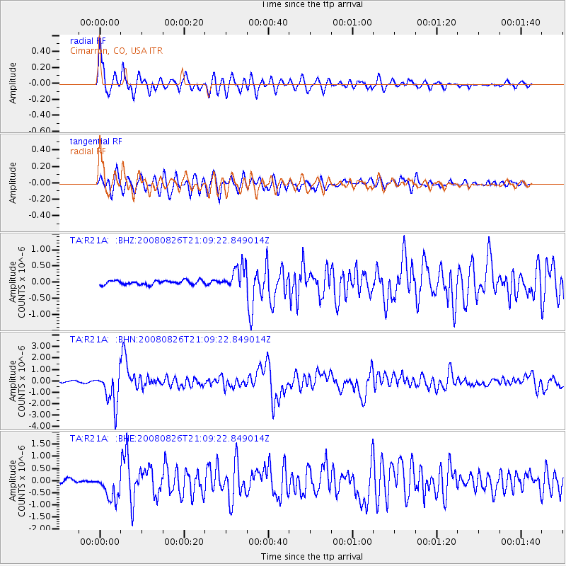
Signal To Noise
| Channel | StoN | STA | LTA |
| TA:R21A: :BHN:20080826T21:09:22.849014Z | 22.064272 | 1.5120277E-6 | 6.852832E-8 |
| TA:R21A: :BHE:20080826T21:09:22.849014Z | 4.986242 | 5.517504E-7 | 1.1065456E-7 |
| TA:R21A: :BHZ:20080826T21:09:22.849014Z | 5.886863 | 3.727927E-7 | 6.3326205E-8 |
| Arrivals |
| Ps | 5.6 SECOND |
| PpPs | 20 SECOND |
| PsPs/PpSs | 26 SECOND |


