You are here: Home > Network List > CI - Caltech Regional Seismic Network Stations List
> Station LRL Laurel Mtn Radio Fac, Ridgecrest, CA, USA > Earthquake Result Viewer
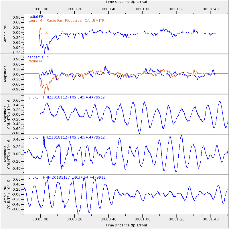
LRL Laurel Mtn Radio Fac, Ridgecrest, CA, USA - Earthquake Result Viewer
*The percent match for this event was below the threshold and hence no stack was calculated.
| Earthquake location: |
Solomon Islands |
| Earthquake latitude/longitude: |
-7.1/154.8 |
| Earthquake time(UTC): |
2018/11/27 (331) 09:22:16 GMT |
| Earthquake Depth: |
10 km |
| Earthquake Magnitude: |
5.5 mb |
| Earthquake Catalog/Contributor: |
NEIC PDE/us |
|
| Network: |
CI Caltech Regional Seismic Network |
| Station: |
LRL Laurel Mtn Radio Fac, Ridgecrest, CA, USA |
| Lat/Lon: |
35.48 N/117.68 W |
| Elevation: |
1340 m |
|
| Distance: |
92.1 deg |
| Az: |
54.682 deg |
| Baz: |
262.859 deg |
| Ray Param: |
$rayparam |
*The percent match for this event was below the threshold and hence was not used in the summary stack. |
|
| Radial Match: |
56.79672 % |
| Radial Bump: |
400 |
| Transverse Match: |
32.627598 % |
| Transverse Bump: |
400 |
| SOD ConfigId: |
13570011 |
| Insert Time: |
2019-05-01 22:17:02.798 +0000 |
| GWidth: |
2.5 |
| Max Bumps: |
400 |
| Tol: |
0.001 |
|
Signal To Noise
| Channel | StoN | STA | LTA |
| CI:LRL: :HHZ:20181127T09:34:54.447991Z | 1.1739604 | 1.9856255E-7 | 1.6913904E-7 |
| CI:LRL: :HHN:20181127T09:34:54.447991Z | 1.6481702 | 4.4076683E-7 | 2.67428E-7 |
| CI:LRL: :HHE:20181127T09:34:54.447991Z | 1.2117151 | 2.1498099E-7 | 1.7741874E-7 |
| Arrivals |
| Ps | |
| PpPs | |
| PsPs/PpSs | |


