You are here: Home > Network List > TA - USArray Transportable Network (new EarthScope stations) Stations List
> Station R21A Cimarron, CO, USA > Earthquake Result Viewer
R21A Cimarron, CO, USA - Earthquake Result Viewer
| Earthquake location: |
Santa Cruz Islands Region |
| Earthquake latitude/longitude: |
-11.0/164.5 |
| Earthquake time(UTC): |
2008/07/19 (201) 09:27:01 GMT |
| Earthquake Depth: |
11 km |
| Earthquake Magnitude: |
6.1 MB, 6.4 MS, 6.6 MW, 6.6 MW |
| Earthquake Catalog/Contributor: |
WHDF/NEIC |
|
| Network: |
TA USArray Transportable Network (new EarthScope stations) |
| Station: |
R21A Cimarron, CO, USA |
| Lat/Lon: |
38.37 N/107.55 W |
| Elevation: |
2260 m |
|
| Distance: |
95.2 deg |
| Az: |
52.07 deg |
| Baz: |
260.102 deg |
| Ray Param: |
0.04085298 |
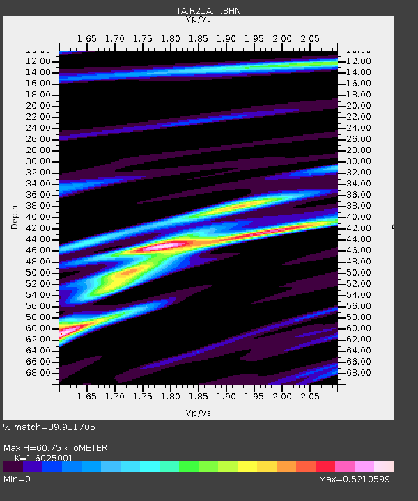
| Estimated Moho Depth: |
60.75 km |
| Estimated Crust Vp/Vs: |
1.60 |
| Assumed Crust Vp: |
6.306 km/s |
| Estimated Crust Vs: |
3.935 km/s |
| Estimated Crust Poisson's Ratio: |
0.18 |
|
| Radial Match: |
89.911705 % |
| Radial Bump: |
400 |
| Transverse Match: |
68.94411 % |
| Transverse Bump: |
400 |
| SOD ConfigId: |
2658 |
| Insert Time: |
2010-03-06 18:15:56.817 +0000 |
| GWidth: |
2.5 |
| Max Bumps: |
400 |
| Tol: |
0.001 |
|

Signal To Noise
| Channel | StoN | STA | LTA |
| TA:R21A: :BHN:20080719T09:39:53.050027Z | 12.646648 | 8.434487E-7 | 6.669345E-8 |
| TA:R21A: :BHE:20080719T09:39:53.050027Z | 1.0466361 | 9.826838E-8 | 9.388973E-8 |
| TA:R21A: :BHZ:20080719T09:39:53.050027Z | 3.3118825 | 2.5357897E-7 | 7.6566415E-8 |
| Arrivals |
| Ps | 5.9 SECOND |
| PpPs | 25 SECOND |
| PsPs/PpSs | 30 SECOND |


