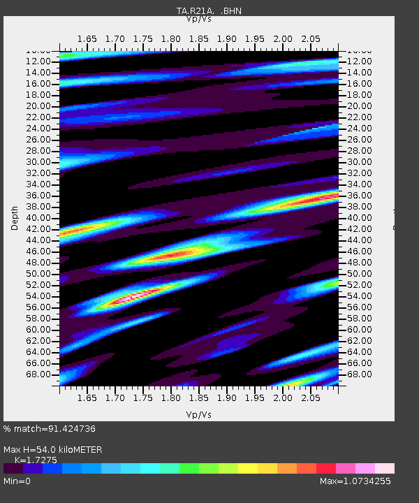
R21A Cimarron, CO, USA - Earthquake Result Viewer

Earthquake location: Near East Coast Of Honshu, Japan
Earthquake latitude/longitude: 35.5/140.9
Earthquake time(UTC): 2009/06/06 (157) 05:52:43 GMT
Earthquake Depth: 34 km
Earthquake Magnitude: 5.8 MB, 5.4 MS, 5.8 MW, 5.7 MW
Earthquake Catalog/Contributor: WHDF/NEIC
Network: TA USArray Transportable Network (new EarthScope stations)
Station: R21A Cimarron, CO, USA
Lat/Lon: 38.37 N/107.55 W
Elevation: 2260 m
Distance: 83.0 deg
Az: 47.448 deg
Baz: 310.108 deg
Ray Param: 0.046445377
Estimated Moho Depth: 54.0 km
Estimated Crust Vp/Vs: 1.73
Assumed Crust Vp: 6.306 km/s
Estimated Crust Vs: 3.65 km/s
Estimated Crust Poisson's Ratio: 0.25
Radial Match: 91.424736 %
Radial Bump: 400
Transverse Match: 90.1571 %
Transverse Bump: 400
SOD ConfigId: 2648
Insert Time: 2010-03-06 18:16:29.471 +0000
GWidth: 2.5
Max Bumps: 400
Tol: 0.001

Signal To Noise

ChannelStoNSTALTA
TA:R21A: :BHN:20090606T06:04:33.950024Z17.3632981.0077664E-65.804003E-8
TA:R21A: :BHE:20090606T06:04:33.950024Z4.39547542.5055715E-75.7003426E-8
TA:R21A: :BHZ:20090606T06:04:33.950024Z8.0885213.5115445E-74.3413927E-8
Arrivals
Ps6.4 SECOND
PpPs23 SECOND
PsPs/PpSs29 SECOND