You are here: Home > Network List > TA - USArray Transportable Network (new EarthScope stations) Stations List
> Station A36M Sachs Harbour, NT, CAN > Earthquake Result Viewer
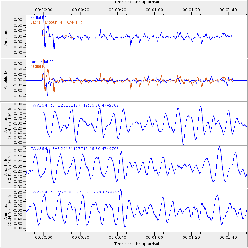
A36M Sachs Harbour, NT, CAN - Earthquake Result Viewer
*The percent match for this event was below the threshold and hence no stack was calculated.
| Earthquake location: |
North Of Ascension Island |
| Earthquake latitude/longitude: |
-1.0/-13.7 |
| Earthquake time(UTC): |
2018/11/27 (331) 12:03:28 GMT |
| Earthquake Depth: |
10 km |
| Earthquake Magnitude: |
5.8 Mww |
| Earthquake Catalog/Contributor: |
NEIC PDE/us |
|
| Network: |
TA USArray Transportable Network (new EarthScope stations) |
| Station: |
A36M Sachs Harbour, NT, CAN |
| Lat/Lon: |
71.99 N/125.25 W |
| Elevation: |
32 m |
|
| Distance: |
97.5 deg |
| Az: |
343.033 deg |
| Baz: |
69.695 deg |
| Ray Param: |
$rayparam |
*The percent match for this event was below the threshold and hence was not used in the summary stack. |
|
| Radial Match: |
77.736755 % |
| Radial Bump: |
400 |
| Transverse Match: |
71.18143 % |
| Transverse Bump: |
358 |
| SOD ConfigId: |
13570011 |
| Insert Time: |
2019-05-01 22:29:00.457 +0000 |
| GWidth: |
2.5 |
| Max Bumps: |
400 |
| Tol: |
0.001 |
|
Signal To Noise
| Channel | StoN | STA | LTA |
| TA:A36M: :BHZ:20181127T12:16:30.474976Z | 2.4584444 | 4.0976437E-7 | 1.6667629E-7 |
| TA:A36M: :BHN:20181127T12:16:30.474976Z | 1.5147154 | 4.070462E-7 | 2.6872783E-7 |
| TA:A36M: :BHE:20181127T12:16:30.474976Z | 1.2541174 | 4.070135E-7 | 3.2454176E-7 |
| Arrivals |
| Ps | |
| PpPs | |
| PsPs/PpSs | |


