You are here: Home > Network List > US - United States National Seismic Network Stations List
> Station DUG Dugway, Tooele County, Utah, USA > Earthquake Result Viewer
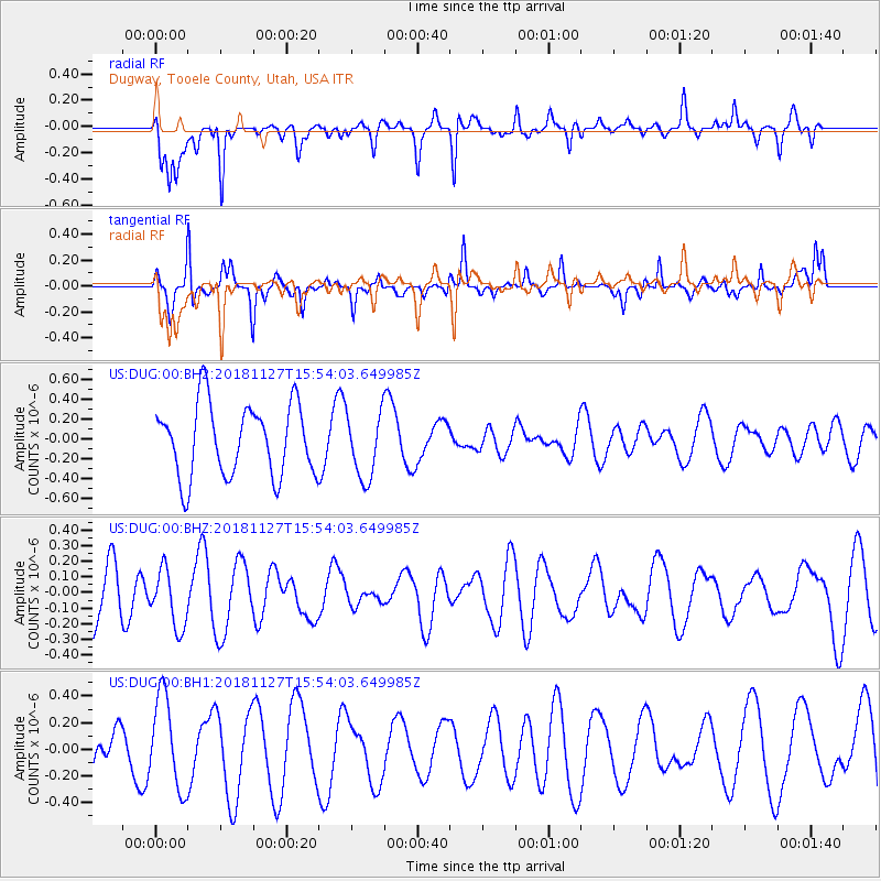
DUG Dugway, Tooele County, Utah, USA - Earthquake Result Viewer
*The percent match for this event was below the threshold and hence no stack was calculated.
| Earthquake location: |
Southeast Of Loyalty Islands |
| Earthquake latitude/longitude: |
-21.3/171.3 |
| Earthquake time(UTC): |
2018/11/27 (331) 15:41:20 GMT |
| Earthquake Depth: |
10 km |
| Earthquake Magnitude: |
5.8 Mww |
| Earthquake Catalog/Contributor: |
NEIC PDE/us |
|
| Network: |
US United States National Seismic Network |
| Station: |
DUG Dugway, Tooele County, Utah, USA |
| Lat/Lon: |
40.19 N/112.81 W |
| Elevation: |
1477 m |
|
| Distance: |
93.3 deg |
| Az: |
48.071 deg |
| Baz: |
244.886 deg |
| Ray Param: |
$rayparam |
*The percent match for this event was below the threshold and hence was not used in the summary stack. |
|
| Radial Match: |
55.718765 % |
| Radial Bump: |
349 |
| Transverse Match: |
76.6651 % |
| Transverse Bump: |
288 |
| SOD ConfigId: |
13570011 |
| Insert Time: |
2019-05-01 22:36:31.188 +0000 |
| GWidth: |
2.5 |
| Max Bumps: |
400 |
| Tol: |
0.001 |
|
Signal To Noise
| Channel | StoN | STA | LTA |
| US:DUG:00:BHZ:20181127T15:54:03.649985Z | 0.5661238 | 1.8667014E-7 | 3.2973378E-7 |
| US:DUG:00:BH1:20181127T15:54:03.649985Z | 2.1021147 | 3.4597903E-7 | 1.6458617E-7 |
| US:DUG:00:BH2:20181127T15:54:03.649985Z | 0.9145573 | 3.3027501E-7 | 3.6113104E-7 |
| Arrivals |
| Ps | |
| PpPs | |
| PsPs/PpSs | |


