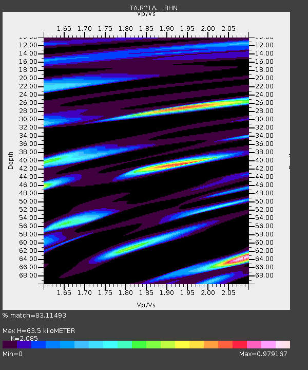
R21A Cimarron, CO, USA - Earthquake Result Viewer

Earthquake location: Kodiak Island Region, Alaska
Earthquake latitude/longitude: 56.5/-152.7
Earthquake time(UTC): 2009/03/30 (089) 07:13:07 GMT
Earthquake Depth: 21 km
Earthquake Magnitude: 5.9 MB, 5.9 MS, 5.9 MW, 5.9 MW
Earthquake Catalog/Contributor: WHDF/NEIC
Network: TA USArray Transportable Network (new EarthScope stations)
Station: R21A Cimarron, CO, USA
Lat/Lon: 38.37 N/107.55 W
Elevation: 2260 m
Distance: 34.8 deg
Az: 102.032 deg
Baz: 316.441 deg
Ray Param: 0.07754594
Estimated Moho Depth: 63.5 km
Estimated Crust Vp/Vs: 2.09
Assumed Crust Vp: 6.306 km/s
Estimated Crust Vs: 3.024 km/s
Estimated Crust Poisson's Ratio: 0.35
Radial Match: 83.11493 %
Radial Bump: 400
Transverse Match: 67.38003 %
Transverse Bump: 400
SOD ConfigId: 2658
Insert Time: 2010-03-06 18:17:02.415 +0000
GWidth: 2.5
Max Bumps: 400
Tol: 0.001

Signal To Noise

ChannelStoNSTALTA
TA:R21A: :BHN:20090330T07:19:25.450013Z8.0488259.913533E-71.2316745E-7
TA:R21A: :BHE:20090330T07:19:25.450013Z2.91233474.91486E-71.6876012E-7
TA:R21A: :BHZ:20090330T07:19:25.450013Z3.7836055.278797E-71.3951765E-7
Arrivals
Ps12 SECOND
PpPs29 SECOND
PsPs/PpSs41 SECOND