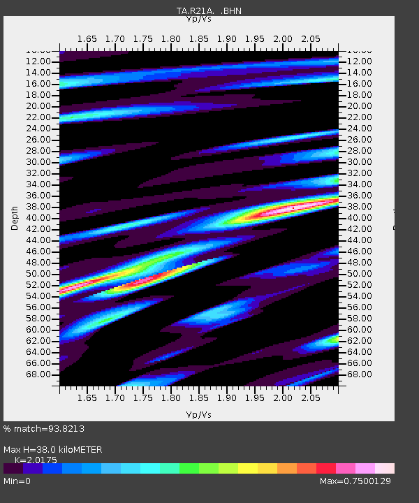
R21A Cimarron, CO, USA - Earthquake Result Viewer

Earthquake location: Andreanof Islands, Aleutian Is.
Earthquake latitude/longitude: 51.9/-177.5
Earthquake time(UTC): 2008/05/02 (123) 01:33:37 GMT
Earthquake Depth: 14 km
Earthquake Magnitude: 6.3 MB, 6.8 MS, 6.6 MW, 6.6 MW
Earthquake Catalog/Contributor: WHDF/NEIC
Network: TA USArray Transportable Network (new EarthScope stations)
Station: R21A Cimarron, CO, USA
Lat/Lon: 38.37 N/107.55 W
Elevation: 2260 m
Distance: 49.3 deg
Az: 76.877 deg
Baz: 309.801 deg
Ray Param: 0.068765946
Estimated Moho Depth: 38.0 km
Estimated Crust Vp/Vs: 2.02
Assumed Crust Vp: 6.306 km/s
Estimated Crust Vs: 3.126 km/s
Estimated Crust Poisson's Ratio: 0.34
Radial Match: 93.8213 %
Radial Bump: 361
Transverse Match: 85.05326 %
Transverse Bump: 400
SOD ConfigId: 2504
Insert Time: 2010-03-06 18:17:26.552 +0000
GWidth: 2.5
Max Bumps: 400
Tol: 0.001

Signal To Noise

ChannelStoNSTALTA
TA:R21A: :BHN:20080502T01:41:54.824015Z8.6796681.3606779E-61.5676612E-7
TA:R21A: :BHE:20080502T01:41:54.824015Z3.77414943.7410038E-79.912177E-8
TA:R21A: :BHZ:20080502T01:41:54.824015Z5.19664575.7231915E-71.1013241E-7
Arrivals
Ps6.4 SECOND
PpPs17 SECOND
PsPs/PpSs24 SECOND