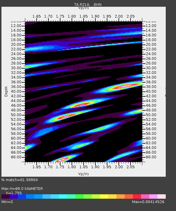
R21A Cimarron, CO, USA - Earthquake Result Viewer

Earthquake location: Rat Islands, Aleutian Islands
Earthquake latitude/longitude: 51.2/178.8
Earthquake time(UTC): 2008/05/20 (141) 13:53:35 GMT
Earthquake Depth: 27 km
Earthquake Magnitude: 5.8 MB, 6.0 MS, 6.3 MW, 6.3 MW
Earthquake Catalog/Contributor: WHDF/NEIC
Network: TA USArray Transportable Network (new EarthScope stations)
Station: R21A Cimarron, CO, USA
Lat/Lon: 38.37 N/107.55 W
Elevation: 2260 m
Distance: 51.7 deg
Az: 73.9 deg
Baz: 309.679 deg
Ray Param: 0.06716895
Estimated Moho Depth: 69.0 km
Estimated Crust Vp/Vs: 1.75
Assumed Crust Vp: 6.306 km/s
Estimated Crust Vs: 3.593 km/s
Estimated Crust Poisson's Ratio: 0.26
Radial Match: 81.59984 %
Radial Bump: 400
Transverse Match: 81.745514 %
Transverse Bump: 400
SOD ConfigId: 2504
Insert Time: 2010-03-06 18:17:33.628 +0000
GWidth: 2.5
Max Bumps: 400
Tol: 0.001

Signal To Noise

ChannelStoNSTALTA
TA:R21A: :BHN:20080520T14:02:09.824021Z7.7172189.767858E-71.2657227E-7
TA:R21A: :BHE:20080520T14:02:09.824021Z1.0361842.0492945E-71.9777323E-7
TA:R21A: :BHZ:20080520T14:02:09.824021Z2.0704423.3937897E-71.6391621E-7
Arrivals
Ps8.7 SECOND
PpPs29 SECOND
PsPs/PpSs37 SECOND