You are here: Home > Network List > TA - USArray Transportable Network (new EarthScope stations) Stations List
> Station R21A Cimarron, CO, USA > Earthquake Result Viewer
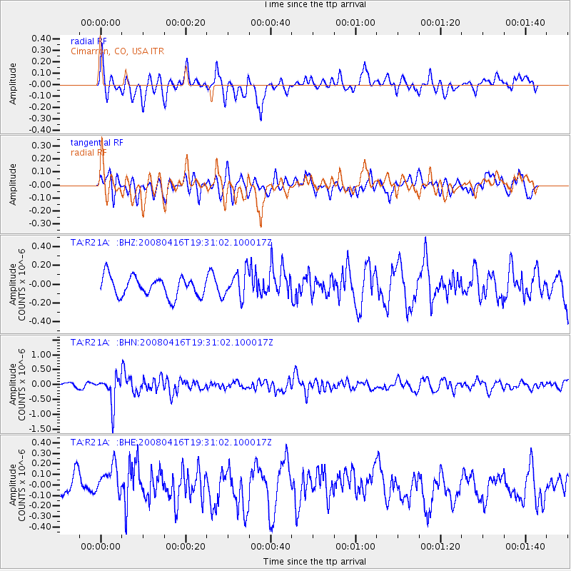
R21A Cimarron, CO, USA - Earthquake Result Viewer
*The percent match for this event was below the threshold and hence no stack was calculated.
| Earthquake location: |
Eastern Honshu, Japan |
| Earthquake latitude/longitude: |
39.0/140.0 |
| Earthquake time(UTC): |
2008/04/16 (107) 19:19:36 GMT |
| Earthquake Depth: |
166 km |
| Earthquake Magnitude: |
5.6 MB, 5.8 MW, 5.8 MW |
| Earthquake Catalog/Contributor: |
WHDF/NEIC |
|
| Network: |
TA USArray Transportable Network (new EarthScope stations) |
| Station: |
R21A Cimarron, CO, USA |
| Lat/Lon: |
38.37 N/107.55 W |
| Elevation: |
2260 m |
|
| Distance: |
81.1 deg |
| Az: |
47.33 deg |
| Baz: |
313.233 deg |
| Ray Param: |
$rayparam |
*The percent match for this event was below the threshold and hence was not used in the summary stack. |
|
| Radial Match: |
61.089684 % |
| Radial Bump: |
400 |
| Transverse Match: |
49.206825 % |
| Transverse Bump: |
400 |
| SOD ConfigId: |
2504 |
| Insert Time: |
2010-03-06 18:17:52.468 +0000 |
| GWidth: |
2.5 |
| Max Bumps: |
400 |
| Tol: |
0.001 |
|
Signal To Noise
| Channel | StoN | STA | LTA |
| TA:R21A: :BHN:20080416T19:31:02.100017Z | 6.1660585 | 4.8971225E-7 | 7.942063E-8 |
| TA:R21A: :BHE:20080416T19:31:02.100017Z | 1.6654316 | 1.7750202E-7 | 1.0658019E-7 |
| TA:R21A: :BHZ:20080416T19:31:02.100017Z | 1.3682823 | 1.4287043E-7 | 1.044159E-7 |
| Arrivals |
| Ps | |
| PpPs | |
| PsPs/PpSs | |


