You are here: Home > Network List > TA - USArray Transportable Network (new EarthScope stations) Stations List
> Station R21A Cimarron, CO, USA > Earthquake Result Viewer
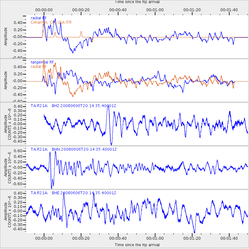
R21A Cimarron, CO, USA - Earthquake Result Viewer
*The percent match for this event was below the threshold and hence no stack was calculated.
| Earthquake location: |
Northern Algeria |
| Earthquake latitude/longitude: |
35.9/-0.7 |
| Earthquake time(UTC): |
2008/06/06 (158) 20:02:56 GMT |
| Earthquake Depth: |
4.0 km |
| Earthquake Magnitude: |
5.5 MB, 5.3 MS, 5.5 MW, 5.5 MW |
| Earthquake Catalog/Contributor: |
WHDF/NEIC |
|
| Network: |
TA USArray Transportable Network (new EarthScope stations) |
| Station: |
R21A Cimarron, CO, USA |
| Lat/Lon: |
38.37 N/107.55 W |
| Elevation: |
2260 m |
|
| Distance: |
79.9 deg |
| Az: |
310.185 deg |
| Baz: |
52.116 deg |
| Ray Param: |
$rayparam |
*The percent match for this event was below the threshold and hence was not used in the summary stack. |
|
| Radial Match: |
63.25781 % |
| Radial Bump: |
400 |
| Transverse Match: |
53.40618 % |
| Transverse Bump: |
400 |
| SOD ConfigId: |
2504 |
| Insert Time: |
2010-03-06 18:17:56.250 +0000 |
| GWidth: |
2.5 |
| Max Bumps: |
400 |
| Tol: |
0.001 |
|
Signal To Noise
| Channel | StoN | STA | LTA |
| TA:R21A: :BHN:20080606T20:14:35.40001Z | 3.962426 | 3.0757514E-7 | 7.7622936E-8 |
| TA:R21A: :BHE:20080606T20:14:35.40001Z | 1.4619025 | 1.2572636E-7 | 8.6001876E-8 |
| TA:R21A: :BHZ:20080606T20:14:35.40001Z | 2.4501452 | 2.0860985E-7 | 8.514183E-8 |
| Arrivals |
| Ps | |
| PpPs | |
| PsPs/PpSs | |


