You are here: Home > Network List > TA - USArray Transportable Network (new EarthScope stations) Stations List
> Station 121A Cookes Peak, Deming, NM, USA > Earthquake Result Viewer
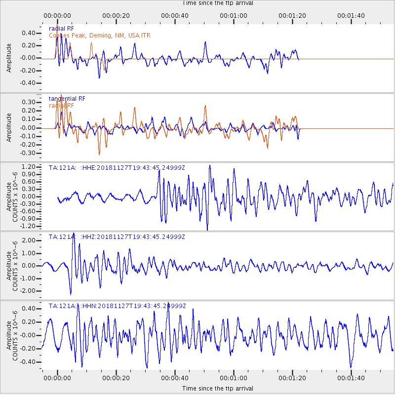
121A Cookes Peak, Deming, NM, USA - Earthquake Result Viewer
*The percent match for this event was below the threshold and hence no stack was calculated.
| Earthquake location: |
North Atlantic Ocean |
| Earthquake latitude/longitude: |
15.6/-49.9 |
| Earthquake time(UTC): |
2018/11/27 (331) 19:34:46 GMT |
| Earthquake Depth: |
10 km |
| Earthquake Magnitude: |
5.5 Mww |
| Earthquake Catalog/Contributor: |
NEIC PDE/us |
|
| Network: |
TA USArray Transportable Network (new EarthScope stations) |
| Station: |
121A Cookes Peak, Deming, NM, USA |
| Lat/Lon: |
32.53 N/107.79 W |
| Elevation: |
1652 m |
|
| Distance: |
54.9 deg |
| Az: |
298.957 deg |
| Baz: |
93.412 deg |
| Ray Param: |
$rayparam |
*The percent match for this event was below the threshold and hence was not used in the summary stack. |
|
| Radial Match: |
71.039116 % |
| Radial Bump: |
400 |
| Transverse Match: |
65.42378 % |
| Transverse Bump: |
400 |
| SOD ConfigId: |
13570011 |
| Insert Time: |
2019-05-01 22:45:19.975 +0000 |
| GWidth: |
2.5 |
| Max Bumps: |
400 |
| Tol: |
0.001 |
|
Signal To Noise
| Channel | StoN | STA | LTA |
| TA:121A: :HHZ:20181127T19:43:45.24999Z | 4.309549 | 7.014823E-7 | 1.6277394E-7 |
| TA:121A: :HHN:20181127T19:43:45.24999Z | 1.1839464 | 1.4887954E-7 | 1.2574854E-7 |
| TA:121A: :HHE:20181127T19:43:45.24999Z | 3.0562577 | 3.5334787E-7 | 1.15614554E-7 |
| Arrivals |
| Ps | |
| PpPs | |
| PsPs/PpSs | |


