You are here: Home > Network List > TA - USArray Transportable Network (new EarthScope stations) Stations List
> Station A36M Sachs Harbour, NT, CAN > Earthquake Result Viewer
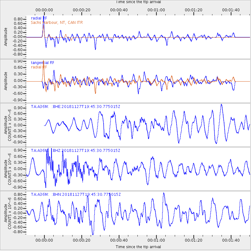
A36M Sachs Harbour, NT, CAN - Earthquake Result Viewer
*The percent match for this event was below the threshold and hence no stack was calculated.
| Earthquake location: |
North Atlantic Ocean |
| Earthquake latitude/longitude: |
15.6/-49.9 |
| Earthquake time(UTC): |
2018/11/27 (331) 19:34:46 GMT |
| Earthquake Depth: |
10 km |
| Earthquake Magnitude: |
5.5 Mww |
| Earthquake Catalog/Contributor: |
NEIC PDE/us |
|
| Network: |
TA USArray Transportable Network (new EarthScope stations) |
| Station: |
A36M Sachs Harbour, NT, CAN |
| Lat/Lon: |
71.99 N/125.25 W |
| Elevation: |
32 m |
|
| Distance: |
70.8 deg |
| Az: |
341.409 deg |
| Baz: |
99.056 deg |
| Ray Param: |
$rayparam |
*The percent match for this event was below the threshold and hence was not used in the summary stack. |
|
| Radial Match: |
56.99155 % |
| Radial Bump: |
400 |
| Transverse Match: |
55.299625 % |
| Transverse Bump: |
400 |
| SOD ConfigId: |
13570011 |
| Insert Time: |
2019-05-01 22:45:23.028 +0000 |
| GWidth: |
2.5 |
| Max Bumps: |
400 |
| Tol: |
0.001 |
|
Signal To Noise
| Channel | StoN | STA | LTA |
| TA:A36M: :BHZ:20181127T19:45:30.775015Z | 2.3073795 | 5.0257376E-7 | 2.1781149E-7 |
| TA:A36M: :BHN:20181127T19:45:30.775015Z | 0.84407556 | 2.8626962E-7 | 3.3915165E-7 |
| TA:A36M: :BHE:20181127T19:45:30.775015Z | 2.8522727 | 5.5646655E-7 | 1.9509584E-7 |
| Arrivals |
| Ps | |
| PpPs | |
| PsPs/PpSs | |


