You are here: Home > Network List > TA - USArray Transportable Network (new EarthScope stations) Stations List
> Station R21A Cimarron, CO, USA > Earthquake Result Viewer
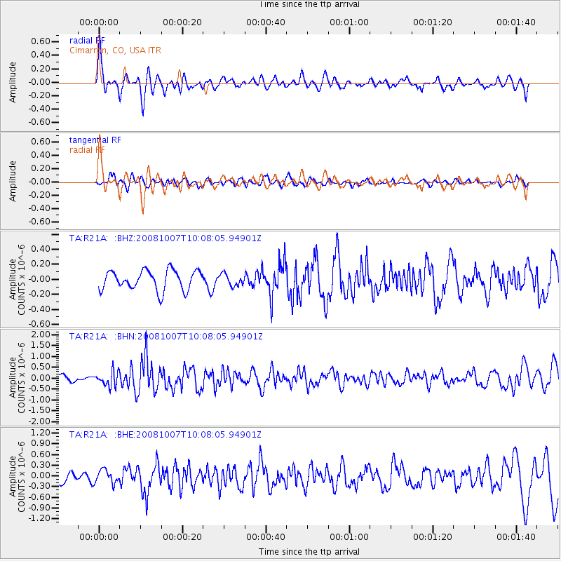
R21A Cimarron, CO, USA - Earthquake Result Viewer
*The percent match for this event was below the threshold and hence no stack was calculated.
| Earthquake location: |
Arctic Ocean |
| Earthquake latitude/longitude: |
79.8/-115.4 |
| Earthquake time(UTC): |
2008/10/07 (281) 10:00:48 GMT |
| Earthquake Depth: |
10 km |
| Earthquake Magnitude: |
5.6 MB, 5.5 MS, 5.7 MW, 5.7 MW |
| Earthquake Catalog/Contributor: |
WHDF/NEIC |
|
| Network: |
TA USArray Transportable Network (new EarthScope stations) |
| Station: |
R21A Cimarron, CO, USA |
| Lat/Lon: |
38.37 N/107.55 W |
| Elevation: |
2260 m |
|
| Distance: |
41.7 deg |
| Az: |
170.653 deg |
| Baz: |
357.893 deg |
| Ray Param: |
$rayparam |
*The percent match for this event was below the threshold and hence was not used in the summary stack. |
|
| Radial Match: |
79.60652 % |
| Radial Bump: |
400 |
| Transverse Match: |
49.16294 % |
| Transverse Bump: |
400 |
| SOD ConfigId: |
2556 |
| Insert Time: |
2010-03-06 18:18:08.719 +0000 |
| GWidth: |
2.5 |
| Max Bumps: |
400 |
| Tol: |
0.001 |
|
Signal To Noise
| Channel | StoN | STA | LTA |
| TA:R21A: :BHN:20081007T10:08:05.94901Z | 2.4964776 | 3.3611843E-7 | 1.3463708E-7 |
| TA:R21A: :BHE:20081007T10:08:05.94901Z | 1.216292 | 1.8265555E-7 | 1.5017409E-7 |
| TA:R21A: :BHZ:20081007T10:08:05.94901Z | 0.60553634 | 7.9289094E-8 | 1.3094026E-7 |
| Arrivals |
| Ps | |
| PpPs | |
| PsPs/PpSs | |


