You are here: Home > Network List > TA - USArray Transportable Network (new EarthScope stations) Stations List
> Station F26K Sheenjek River, AK, USA > Earthquake Result Viewer
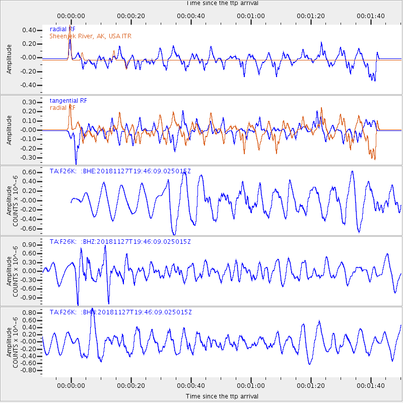
F26K Sheenjek River, AK, USA - Earthquake Result Viewer
*The percent match for this event was below the threshold and hence no stack was calculated.
| Earthquake location: |
North Atlantic Ocean |
| Earthquake latitude/longitude: |
15.6/-49.9 |
| Earthquake time(UTC): |
2018/11/27 (331) 19:34:46 GMT |
| Earthquake Depth: |
10 km |
| Earthquake Magnitude: |
5.5 Mww |
| Earthquake Catalog/Contributor: |
NEIC PDE/us |
|
| Network: |
TA USArray Transportable Network (new EarthScope stations) |
| Station: |
F26K Sheenjek River, AK, USA |
| Lat/Lon: |
67.69 N/144.15 W |
| Elevation: |
683 m |
|
| Distance: |
77.3 deg |
| Az: |
337.033 deg |
| Baz: |
80.092 deg |
| Ray Param: |
$rayparam |
*The percent match for this event was below the threshold and hence was not used in the summary stack. |
|
| Radial Match: |
61.838158 % |
| Radial Bump: |
394 |
| Transverse Match: |
61.356106 % |
| Transverse Bump: |
321 |
| SOD ConfigId: |
13570011 |
| Insert Time: |
2019-05-01 22:45:44.569 +0000 |
| GWidth: |
2.5 |
| Max Bumps: |
400 |
| Tol: |
0.001 |
|
Signal To Noise
| Channel | StoN | STA | LTA |
| TA:F26K: :BHZ:20181127T19:46:09.025015Z | 2.0437274 | 4.4770962E-7 | 2.1906526E-7 |
| TA:F26K: :BHN:20181127T19:46:09.025015Z | 0.97872514 | 2.3107255E-7 | 2.3609546E-7 |
| TA:F26K: :BHE:20181127T19:46:09.025015Z | 1.9371388 | 4.148419E-7 | 2.1415187E-7 |
| Arrivals |
| Ps | |
| PpPs | |
| PsPs/PpSs | |


