You are here: Home > Network List > TA - USArray Transportable Network (new EarthScope stations) Stations List
> Station R21A Cimarron, CO, USA > Earthquake Result Viewer
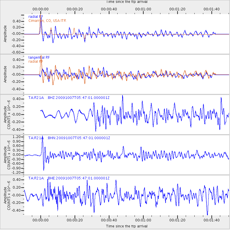
R21A Cimarron, CO, USA - Earthquake Result Viewer
*The percent match for this event was below the threshold and hence no stack was calculated.
| Earthquake location: |
Rat Islands, Aleutian Islands |
| Earthquake latitude/longitude: |
52.2/178.1 |
| Earthquake time(UTC): |
2009/10/07 (280) 05:38:37 GMT |
| Earthquake Depth: |
138 km |
| Earthquake Magnitude: |
5.6 MB, 5.6 MW, 5.6 MW |
| Earthquake Catalog/Contributor: |
WHDF/NEIC |
|
| Network: |
TA USArray Transportable Network (new EarthScope stations) |
| Station: |
R21A Cimarron, CO, USA |
| Lat/Lon: |
38.37 N/107.55 W |
| Elevation: |
2260 m |
|
| Distance: |
51.9 deg |
| Az: |
74.196 deg |
| Baz: |
311.052 deg |
| Ray Param: |
$rayparam |
*The percent match for this event was below the threshold and hence was not used in the summary stack. |
|
| Radial Match: |
67.40545 % |
| Radial Bump: |
400 |
| Transverse Match: |
62.993015 % |
| Transverse Bump: |
400 |
| SOD ConfigId: |
2622 |
| Insert Time: |
2010-03-06 18:18:27.163 +0000 |
| GWidth: |
2.5 |
| Max Bumps: |
400 |
| Tol: |
0.001 |
|
Signal To Noise
| Channel | StoN | STA | LTA |
| TA:R21A: :BHN:20091007T05:47:01.000001Z | 9.2182255 | 5.113437E-7 | 5.5470952E-8 |
| TA:R21A: :BHE:20091007T05:47:01.000001Z | 1.792642 | 1.4816943E-7 | 8.2654225E-8 |
| TA:R21A: :BHZ:20091007T05:47:01.000001Z | 2.437165 | 1.8902016E-7 | 7.755739E-8 |
| Arrivals |
| Ps | |
| PpPs | |
| PsPs/PpSs | |


