You are here: Home > Network List > YN10 - San Jacinto Fault Zone Stations List
> Station GVAR1 GVAR1, Anza, CA, USA > Earthquake Result Viewer
GVAR1 GVAR1, Anza, CA, USA - Earthquake Result Viewer
| Earthquake location: |
North Atlantic Ocean |
| Earthquake latitude/longitude: |
15.6/-49.9 |
| Earthquake time(UTC): |
2018/11/27 (331) 19:34:46 GMT |
| Earthquake Depth: |
10 km |
| Earthquake Magnitude: |
5.5 Mww |
| Earthquake Catalog/Contributor: |
NEIC PDE/us |
|
| Network: |
YN San Jacinto Fault Zone |
| Station: |
GVAR1 GVAR1, Anza, CA, USA |
| Lat/Lon: |
33.67 N/116.71 W |
| Elevation: |
1328 m |
|
| Distance: |
62.4 deg |
| Az: |
300.082 deg |
| Baz: |
89.143 deg |
| Ray Param: |
0.060274415 |
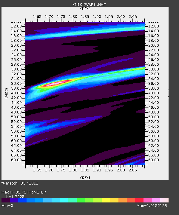
| Estimated Moho Depth: |
35.75 km |
| Estimated Crust Vp/Vs: |
1.72 |
| Assumed Crust Vp: |
6.264 km/s |
| Estimated Crust Vs: |
3.636 km/s |
| Estimated Crust Poisson's Ratio: |
0.25 |
|
| Radial Match: |
83.41011 % |
| Radial Bump: |
187 |
| Transverse Match: |
81.59608 % |
| Transverse Bump: |
213 |
| SOD ConfigId: |
13570011 |
| Insert Time: |
2019-05-01 22:47:48.615 +0000 |
| GWidth: |
2.5 |
| Max Bumps: |
400 |
| Tol: |
0.001 |
|

Signal To Noise
| Channel | StoN | STA | LTA |
| YN:GVAR1: :HHZ:20181127T19:44:37.444021Z | 2.1078522 | 3.3177187E-7 | 1.5739808E-7 |
| YN:GVAR1: :HHN:20181127T19:44:37.444021Z | 1.0942986 | 1.6186461E-5 | 1.4791631E-5 |
| YN:GVAR1: :HHE:20181127T19:44:37.444021Z | 1.2324694 | 2.1411114E-7 | 1.7372531E-7 |
| Arrivals |
| Ps | 4.3 SECOND |
| PpPs | 15 SECOND |
| PsPs/PpSs | 19 SECOND |


