You are here: Home > Network List > TA - USArray Transportable Network (new EarthScope stations) Stations List
> Station R21A Cimarron, CO, USA > Earthquake Result Viewer
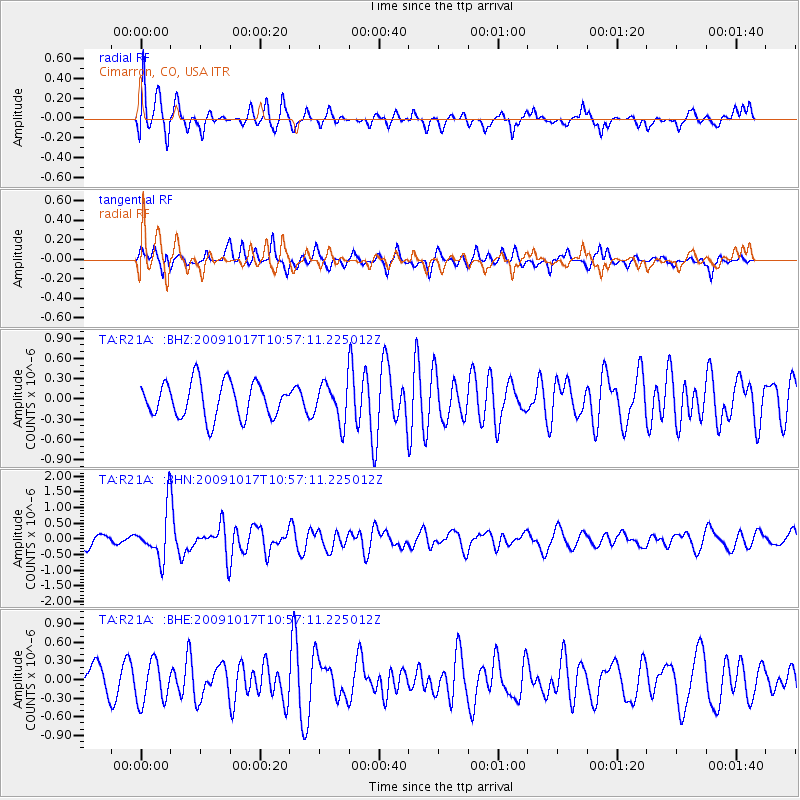
R21A Cimarron, CO, USA - Earthquake Result Viewer
*The percent match for this event was below the threshold and hence no stack was calculated.
| Earthquake location: |
Samoa Islands Region |
| Earthquake latitude/longitude: |
-16.4/-172.0 |
| Earthquake time(UTC): |
2009/10/17 (290) 10:45:26 GMT |
| Earthquake Depth: |
10 km |
| Earthquake Magnitude: |
5.7 MB, 5.3 MS, 5.7 MW, 5.7 MW |
| Earthquake Catalog/Contributor: |
WHDF/NEIC |
|
| Network: |
TA USArray Transportable Network (new EarthScope stations) |
| Station: |
R21A Cimarron, CO, USA |
| Lat/Lon: |
38.37 N/107.55 W |
| Elevation: |
2260 m |
|
| Distance: |
81.2 deg |
| Az: |
45.849 deg |
| Baz: |
241.196 deg |
| Ray Param: |
$rayparam |
*The percent match for this event was below the threshold and hence was not used in the summary stack. |
|
| Radial Match: |
73.03318 % |
| Radial Bump: |
400 |
| Transverse Match: |
49.365246 % |
| Transverse Bump: |
302 |
| SOD ConfigId: |
2622 |
| Insert Time: |
2010-03-06 18:18:39.591 +0000 |
| GWidth: |
2.5 |
| Max Bumps: |
400 |
| Tol: |
0.001 |
|
Signal To Noise
| Channel | StoN | STA | LTA |
| TA:R21A: :BHN:20091017T10:57:11.225012Z | 4.290774 | 7.625956E-7 | 1.7772916E-7 |
| TA:R21A: :BHE:20091017T10:57:11.225012Z | 1.3881186 | 3.323848E-7 | 2.3944983E-7 |
| TA:R21A: :BHZ:20091017T10:57:11.225012Z | 1.1022769 | 2.8578316E-7 | 2.5926622E-7 |
| Arrivals |
| Ps | |
| PpPs | |
| PsPs/PpSs | |


