You are here: Home > Network List > TS - TERRAscope (Southern California Seismic Network) Stations List
> Station BAR Barrett Dam, California, USA > Earthquake Result Viewer
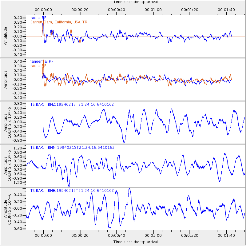
BAR Barrett Dam, California, USA - Earthquake Result Viewer
*The percent match for this event was below the threshold and hence no stack was calculated.
| Earthquake location: |
Loyalty Islands |
| Earthquake latitude/longitude: |
-20.4/168.8 |
| Earthquake time(UTC): |
1994/02/15 (046) 21:11:58 GMT |
| Earthquake Depth: |
33 km |
| Earthquake Magnitude: |
5.6 MB, 6.5 MS, 6.5 UNKNOWN, 6.5 MW |
| Earthquake Catalog/Contributor: |
WHDF/NEIC |
|
| Network: |
TS TERRAscope (Southern California Seismic Network) |
| Station: |
BAR Barrett Dam, California, USA |
| Lat/Lon: |
32.68 N/116.67 W |
| Elevation: |
548 m |
|
| Distance: |
88.5 deg |
| Az: |
54.378 deg |
| Baz: |
244.728 deg |
| Ray Param: |
$rayparam |
*The percent match for this event was below the threshold and hence was not used in the summary stack. |
|
| Radial Match: |
47.8853 % |
| Radial Bump: |
400 |
| Transverse Match: |
60.11091 % |
| Transverse Bump: |
400 |
| SOD ConfigId: |
4480 |
| Insert Time: |
2010-02-26 14:01:14.376 +0000 |
| GWidth: |
2.5 |
| Max Bumps: |
400 |
| Tol: |
0.001 |
|
Signal To Noise
| Channel | StoN | STA | LTA |
| TS:BAR: :BHN:19940215T21:24:16.641016Z | 1.7970351 | 4.277085E-7 | 2.3800787E-7 |
| TS:BAR: :BHE:19940215T21:24:16.641016Z | 1.1110535 | 2.1108731E-7 | 1.8998844E-7 |
| TS:BAR: :BHZ:19940215T21:24:16.641016Z | 1.8214134 | 4.5078892E-7 | 2.47494E-7 |
| Arrivals |
| Ps | |
| PpPs | |
| PsPs/PpSs | |


