You are here: Home > Network List > TA - USArray Transportable Network (new EarthScope stations) Stations List
> Station R21A Cimarron, CO, USA > Earthquake Result Viewer
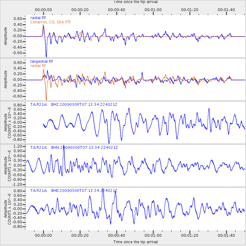
R21A Cimarron, CO, USA - Earthquake Result Viewer
*The percent match for this event was below the threshold and hence no stack was calculated.
| Earthquake location: |
Tonga Islands |
| Earthquake latitude/longitude: |
-15.2/-173.3 |
| Earthquake time(UTC): |
2009/03/06 (065) 07:01:48 GMT |
| Earthquake Depth: |
3.0 km |
| Earthquake Magnitude: |
5.5 MB, 5.4 MS, 5.8 MW, 5.8 MW |
| Earthquake Catalog/Contributor: |
WHDF/NEIC |
|
| Network: |
TA USArray Transportable Network (new EarthScope stations) |
| Station: |
R21A Cimarron, CO, USA |
| Lat/Lon: |
38.37 N/107.55 W |
| Elevation: |
2260 m |
|
| Distance: |
81.3 deg |
| Az: |
46.474 deg |
| Baz: |
242.965 deg |
| Ray Param: |
$rayparam |
*The percent match for this event was below the threshold and hence was not used in the summary stack. |
|
| Radial Match: |
84.700325 % |
| Radial Bump: |
352 |
| Transverse Match: |
55.45796 % |
| Transverse Bump: |
395 |
| SOD ConfigId: |
2658 |
| Insert Time: |
2010-03-06 18:18:54.851 +0000 |
| GWidth: |
2.5 |
| Max Bumps: |
400 |
| Tol: |
0.001 |
|
Signal To Noise
| Channel | StoN | STA | LTA |
| TA:R21A: :BHN:20090306T07:13:34.224021Z | 1.308769 | 3.4548685E-7 | 2.6397848E-7 |
| TA:R21A: :BHE:20090306T07:13:34.224021Z | 0.49766895 | 1.3071636E-7 | 2.6265724E-7 |
| TA:R21A: :BHZ:20090306T07:13:34.224021Z | 2.0344584 | 4.0155015E-7 | 1.9737448E-7 |
| Arrivals |
| Ps | |
| PpPs | |
| PsPs/PpSs | |


