You are here: Home > Network List > TA - USArray Transportable Network (new EarthScope stations) Stations List
> Station R21A Cimarron, CO, USA > Earthquake Result Viewer
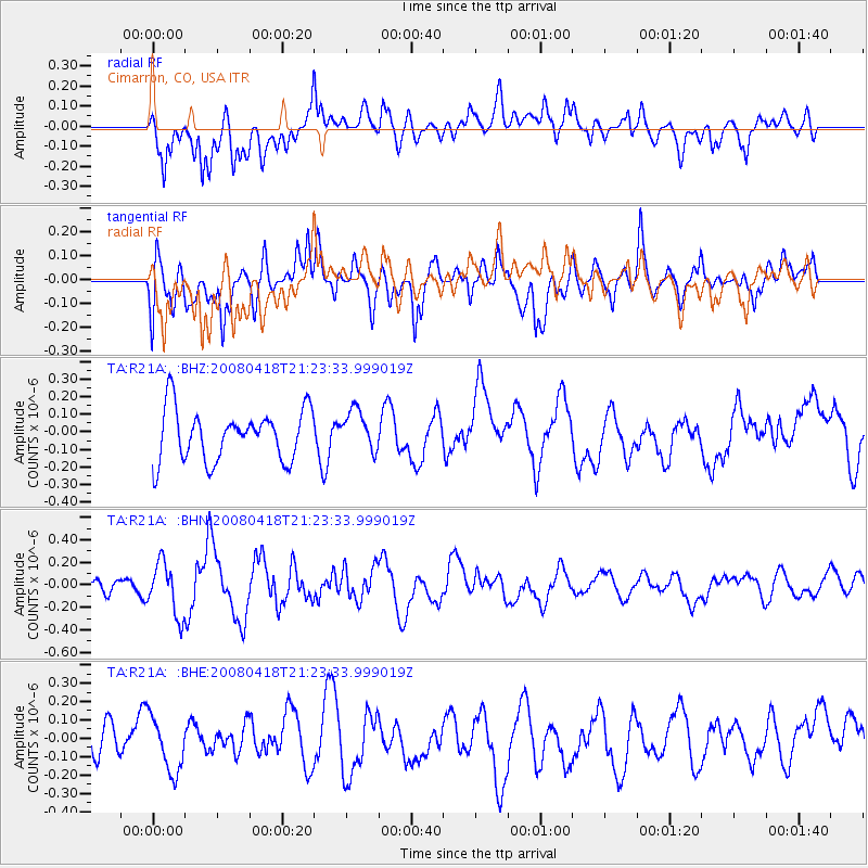
R21A Cimarron, CO, USA - Earthquake Result Viewer
*The percent match for this event was below the threshold and hence no stack was calculated.
| Earthquake location: |
Kermadec Islands Region |
| Earthquake latitude/longitude: |
-27.5/-176.6 |
| Earthquake time(UTC): |
2008/04/18 (109) 21:10:56 GMT |
| Earthquake Depth: |
10 km |
| Earthquake Magnitude: |
5.6 MS, 5.4 MB, 5.8 MW, 5.8 MW |
| Earthquake Catalog/Contributor: |
WHDF/NEIC |
|
| Network: |
TA USArray Transportable Network (new EarthScope stations) |
| Station: |
R21A Cimarron, CO, USA |
| Lat/Lon: |
38.37 N/107.55 W |
| Elevation: |
2260 m |
|
| Distance: |
92.0 deg |
| Az: |
47.259 deg |
| Baz: |
236.07 deg |
| Ray Param: |
$rayparam |
*The percent match for this event was below the threshold and hence was not used in the summary stack. |
|
| Radial Match: |
52.58618 % |
| Radial Bump: |
400 |
| Transverse Match: |
57.481106 % |
| Transverse Bump: |
400 |
| SOD ConfigId: |
2504 |
| Insert Time: |
2010-03-06 18:19:22.084 +0000 |
| GWidth: |
2.5 |
| Max Bumps: |
400 |
| Tol: |
0.001 |
|
Signal To Noise
| Channel | StoN | STA | LTA |
| TA:R21A: :BHN:20080418T21:23:33.999019Z | 3.3520694 | 2.330646E-7 | 6.952857E-8 |
| TA:R21A: :BHE:20080418T21:23:33.999019Z | 0.98125947 | 1.4603621E-7 | 1.4882528E-7 |
| TA:R21A: :BHZ:20080418T21:23:33.999019Z | 0.8058867 | 1.163072E-7 | 1.4432203E-7 |
| Arrivals |
| Ps | |
| PpPs | |
| PsPs/PpSs | |


