You are here: Home > Network List > TS - TERRAscope (Southern California Seismic Network) Stations List
> Station BAR Barrett Dam, California, USA > Earthquake Result Viewer
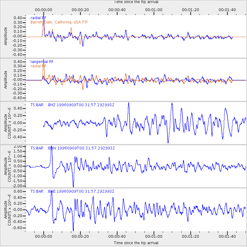
BAR Barrett Dam, California, USA - Earthquake Result Viewer
*The percent match for this event was below the threshold and hence no stack was calculated.
| Earthquake location: |
Near Coast Of Central Chile |
| Earthquake latitude/longitude: |
-31.9/-71.6 |
| Earthquake time(UTC): |
1996/09/09 (253) 00:20:39 GMT |
| Earthquake Depth: |
39 km |
| Earthquake Magnitude: |
6.0 MB, 5.5 MS, 6.0 UNKNOWN, 5.8 ME |
| Earthquake Catalog/Contributor: |
WHDF/NEIC |
|
| Network: |
TS TERRAscope (Southern California Seismic Network) |
| Station: |
BAR Barrett Dam, California, USA |
| Lat/Lon: |
32.68 N/116.67 W |
| Elevation: |
548 m |
|
| Distance: |
77.1 deg |
| Az: |
322.192 deg |
| Baz: |
141.81 deg |
| Ray Param: |
$rayparam |
*The percent match for this event was below the threshold and hence was not used in the summary stack. |
|
| Radial Match: |
79.45422 % |
| Radial Bump: |
400 |
| Transverse Match: |
79.986885 % |
| Transverse Bump: |
400 |
| SOD ConfigId: |
4480 |
| Insert Time: |
2010-02-26 14:01:15.782 +0000 |
| GWidth: |
2.5 |
| Max Bumps: |
400 |
| Tol: |
0.001 |
|
Signal To Noise
| Channel | StoN | STA | LTA |
| TS:BAR: :BHN:19960909T00:31:57.292993Z | 7.4451714 | 7.097508E-7 | 9.533035E-8 |
| TS:BAR: :BHE:19960909T00:31:57.292993Z | 2.8788815 | 2.2340578E-7 | 7.760159E-8 |
| TS:BAR: :BHZ:19960909T00:31:57.292993Z | 2.2463846 | 1.3293501E-7 | 5.9177317E-8 |
| Arrivals |
| Ps | |
| PpPs | |
| PsPs/PpSs | |


