You are here: Home > Network List > TA - USArray Transportable Network (new EarthScope stations) Stations List
> Station R21A Cimarron, CO, USA > Earthquake Result Viewer
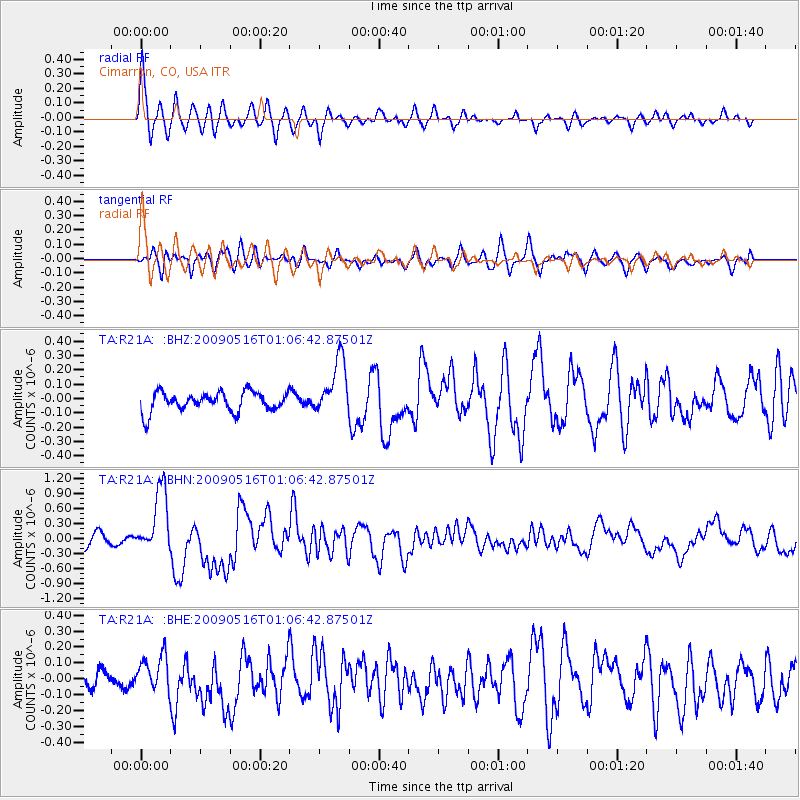
R21A Cimarron, CO, USA - Earthquake Result Viewer
*The percent match for this event was below the threshold and hence no stack was calculated.
| Earthquake location: |
Kermadec Islands Region |
| Earthquake latitude/longitude: |
-31.5/-178.8 |
| Earthquake time(UTC): |
2009/05/16 (136) 00:53:52 GMT |
| Earthquake Depth: |
55 km |
| Earthquake Magnitude: |
6.1 MB, 6.5 MW, 6.3 MW |
| Earthquake Catalog/Contributor: |
WHDF/NEIC |
|
| Network: |
TA USArray Transportable Network (new EarthScope stations) |
| Station: |
R21A Cimarron, CO, USA |
| Lat/Lon: |
38.37 N/107.55 W |
| Elevation: |
2260 m |
|
| Distance: |
96.1 deg |
| Az: |
48.461 deg |
| Baz: |
234.412 deg |
| Ray Param: |
$rayparam |
*The percent match for this event was below the threshold and hence was not used in the summary stack. |
|
| Radial Match: |
76.230576 % |
| Radial Bump: |
400 |
| Transverse Match: |
68.97858 % |
| Transverse Bump: |
400 |
| SOD ConfigId: |
2760 |
| Insert Time: |
2010-03-06 18:19:56.620 +0000 |
| GWidth: |
2.5 |
| Max Bumps: |
400 |
| Tol: |
0.001 |
|
Signal To Noise
| Channel | StoN | STA | LTA |
| TA:R21A: :BHN:20090516T01:06:42.87501Z | 4.8933454 | 6.427499E-7 | 1.3135184E-7 |
| TA:R21A: :BHE:20090516T01:06:42.87501Z | 1.2415348 | 1.12130785E-7 | 9.031627E-8 |
| TA:R21A: :BHZ:20090516T01:06:42.87501Z | 2.9290125 | 1.9686074E-7 | 6.7210614E-8 |
| Arrivals |
| Ps | |
| PpPs | |
| PsPs/PpSs | |


