You are here: Home > Network List > TA - USArray Transportable Network (new EarthScope stations) Stations List
> Station I30M Mount Dempster, Yukon, CAN > Earthquake Result Viewer
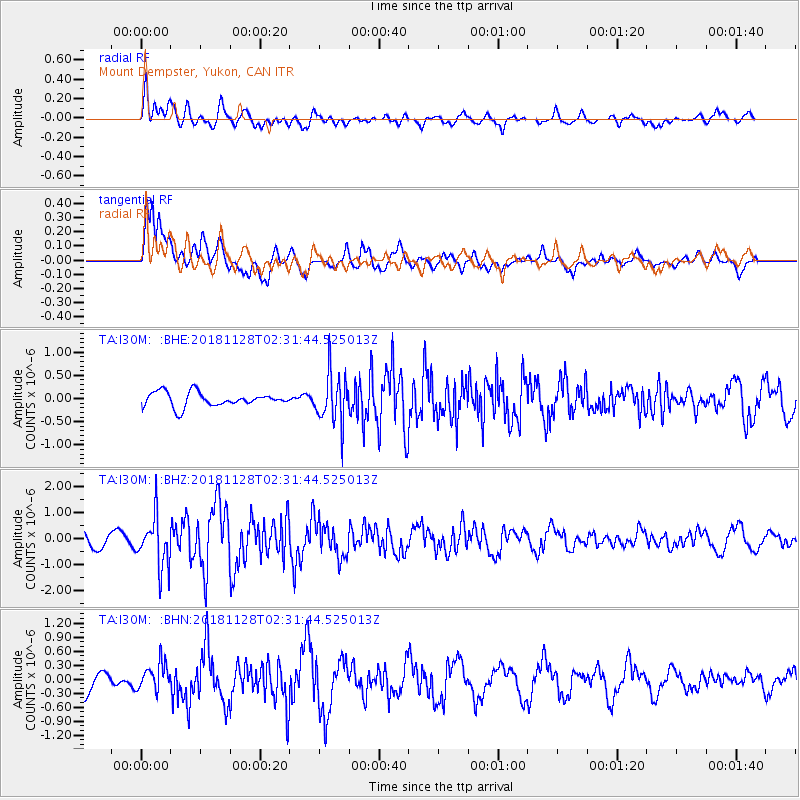
I30M Mount Dempster, Yukon, CAN - Earthquake Result Viewer
*The percent match for this event was below the threshold and hence no stack was calculated.
| Earthquake location: |
Hokkaido, Japan Region |
| Earthquake latitude/longitude: |
41.4/143.3 |
| Earthquake time(UTC): |
2018/11/28 (332) 02:23:24 GMT |
| Earthquake Depth: |
10 km |
| Earthquake Magnitude: |
5.5 Mww |
| Earthquake Catalog/Contributor: |
NEIC PDE/us |
|
| Network: |
TA USArray Transportable Network (new EarthScope stations) |
| Station: |
I30M Mount Dempster, Yukon, CAN |
| Lat/Lon: |
65.22 N/136.38 W |
| Elevation: |
1399 m |
|
| Distance: |
49.5 deg |
| Az: |
33.142 deg |
| Baz: |
282.384 deg |
| Ray Param: |
$rayparam |
*The percent match for this event was below the threshold and hence was not used in the summary stack. |
|
| Radial Match: |
75.54851 % |
| Radial Bump: |
400 |
| Transverse Match: |
73.920074 % |
| Transverse Bump: |
400 |
| SOD ConfigId: |
13570011 |
| Insert Time: |
2019-05-01 22:57:46.638 +0000 |
| GWidth: |
2.5 |
| Max Bumps: |
400 |
| Tol: |
0.001 |
|
Signal To Noise
| Channel | StoN | STA | LTA |
| TA:I30M: :BHZ:20181128T02:31:44.525013Z | 2.6932473 | 9.53826E-7 | 3.541546E-7 |
| TA:I30M: :BHN:20181128T02:31:44.525013Z | 0.7817895 | 2.8243025E-7 | 3.6126124E-7 |
| TA:I30M: :BHE:20181128T02:31:44.525013Z | 3.3120039 | 5.1697447E-7 | 1.5609115E-7 |
| Arrivals |
| Ps | |
| PpPs | |
| PsPs/PpSs | |


