You are here: Home > Network List > TA - USArray Transportable Network (new EarthScope stations) Stations List
> Station L15K Ungalak Mountain, AK, USA > Earthquake Result Viewer
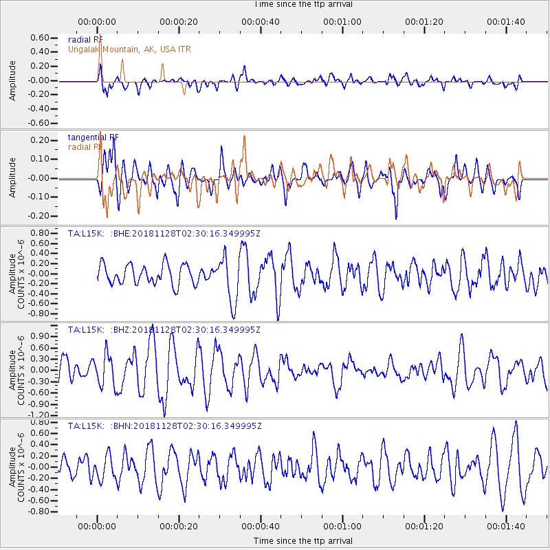
L15K Ungalak Mountain, AK, USA - Earthquake Result Viewer
*The percent match for this event was below the threshold and hence no stack was calculated.
| Earthquake location: |
Hokkaido, Japan Region |
| Earthquake latitude/longitude: |
41.4/143.3 |
| Earthquake time(UTC): |
2018/11/28 (332) 02:23:24 GMT |
| Earthquake Depth: |
10 km |
| Earthquake Magnitude: |
5.5 Mww |
| Earthquake Catalog/Contributor: |
NEIC PDE/us |
|
| Network: |
TA USArray Transportable Network (new EarthScope stations) |
| Station: |
L15K Ungalak Mountain, AK, USA |
| Lat/Lon: |
61.68 N/161.49 W |
| Elevation: |
219 m |
|
| Distance: |
38.4 deg |
| Az: |
39.06 deg |
| Baz: |
264.151 deg |
| Ray Param: |
$rayparam |
*The percent match for this event was below the threshold and hence was not used in the summary stack. |
|
| Radial Match: |
55.59718 % |
| Radial Bump: |
400 |
| Transverse Match: |
62.32184 % |
| Transverse Bump: |
400 |
| SOD ConfigId: |
13570011 |
| Insert Time: |
2019-05-01 22:57:57.265 +0000 |
| GWidth: |
2.5 |
| Max Bumps: |
400 |
| Tol: |
0.001 |
|
Signal To Noise
| Channel | StoN | STA | LTA |
| TA:L15K: :BHZ:20181128T02:30:16.349995Z | 1.2202326 | 4.2902812E-7 | 3.5159536E-7 |
| TA:L15K: :BHN:20181128T02:30:16.349995Z | 1.2428985 | 2.1143575E-7 | 1.7011506E-7 |
| TA:L15K: :BHE:20181128T02:30:16.349995Z | 2.375156 | 4.5632683E-7 | 1.92125E-7 |
| Arrivals |
| Ps | |
| PpPs | |
| PsPs/PpSs | |


