You are here: Home > Network List > TA - USArray Transportable Network (new EarthScope stations) Stations List
> Station T25A Trinidad, CO, USA > Earthquake Result Viewer
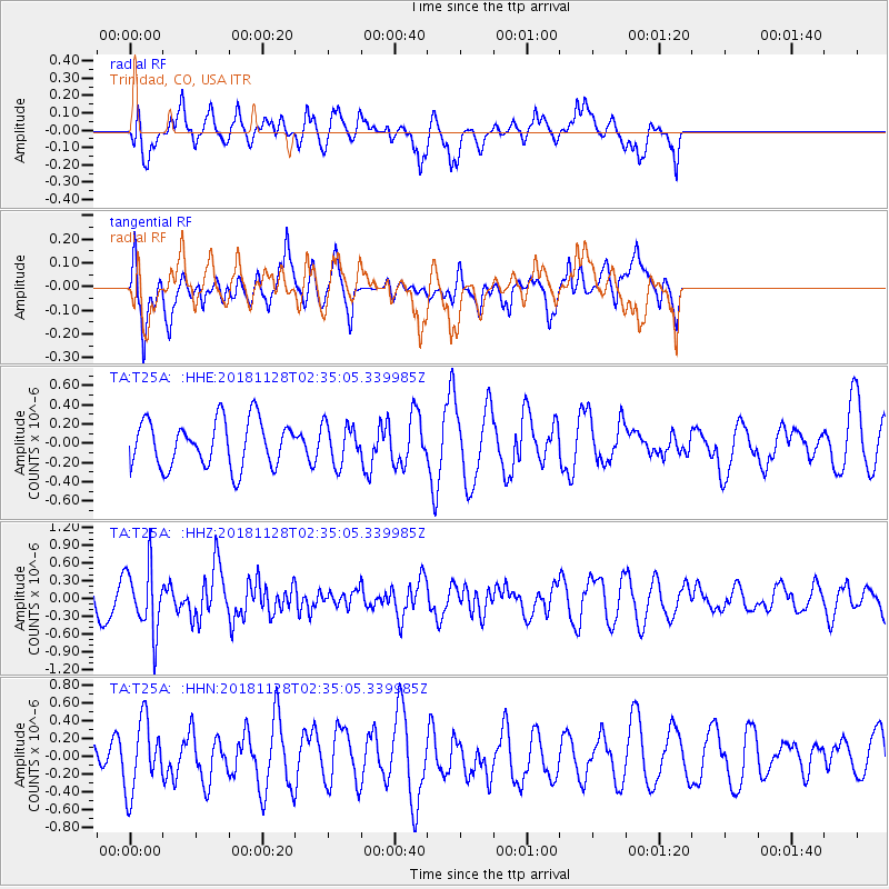
T25A Trinidad, CO, USA - Earthquake Result Viewer
*The percent match for this event was below the threshold and hence no stack was calculated.
| Earthquake location: |
Hokkaido, Japan Region |
| Earthquake latitude/longitude: |
41.4/143.3 |
| Earthquake time(UTC): |
2018/11/28 (332) 02:23:24 GMT |
| Earthquake Depth: |
10 km |
| Earthquake Magnitude: |
5.5 Mww |
| Earthquake Catalog/Contributor: |
NEIC PDE/us |
|
| Network: |
TA USArray Transportable Network (new EarthScope stations) |
| Station: |
T25A Trinidad, CO, USA |
| Lat/Lon: |
37.14 N/104.41 W |
| Elevation: |
2017 m |
|
| Distance: |
80.4 deg |
| Az: |
48.572 deg |
| Baz: |
315.057 deg |
| Ray Param: |
$rayparam |
*The percent match for this event was below the threshold and hence was not used in the summary stack. |
|
| Radial Match: |
57.409653 % |
| Radial Bump: |
400 |
| Transverse Match: |
56.43115 % |
| Transverse Bump: |
400 |
| SOD ConfigId: |
13570011 |
| Insert Time: |
2019-05-01 22:58:26.842 +0000 |
| GWidth: |
2.5 |
| Max Bumps: |
400 |
| Tol: |
0.001 |
|
Signal To Noise
| Channel | StoN | STA | LTA |
| TA:T25A: :HHZ:20181128T02:35:05.339985Z | 2.2647917 | 5.446386E-7 | 2.4048066E-7 |
| TA:T25A: :HHN:20181128T02:35:05.339985Z | 3.1876352 | 4.0080107E-7 | 1.2573618E-7 |
| TA:T25A: :HHE:20181128T02:35:05.339985Z | 0.8554111 | 2.0911993E-7 | 2.4446717E-7 |
| Arrivals |
| Ps | |
| PpPs | |
| PsPs/PpSs | |


