You are here: Home > Network List > TS - TERRAscope (Southern California Seismic Network) Stations List
> Station BAR Barrett Dam, California, USA > Earthquake Result Viewer
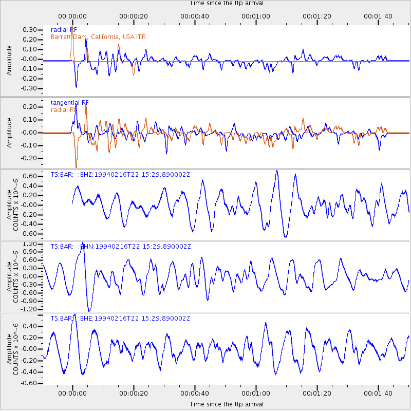
BAR Barrett Dam, California, USA - Earthquake Result Viewer
*The percent match for this event was below the threshold and hence no stack was calculated.
| Earthquake location: |
Loyalty Islands |
| Earthquake latitude/longitude: |
-20.2/168.8 |
| Earthquake time(UTC): |
1994/02/16 (047) 22:03:12 GMT |
| Earthquake Depth: |
33 km |
| Earthquake Magnitude: |
5.6 MB, 5.8 MS, 5.9 UNKNOWN, 6.1 MW |
| Earthquake Catalog/Contributor: |
WHDF/NEIC |
|
| Network: |
TS TERRAscope (Southern California Seismic Network) |
| Station: |
BAR Barrett Dam, California, USA |
| Lat/Lon: |
32.68 N/116.67 W |
| Elevation: |
548 m |
|
| Distance: |
88.5 deg |
| Az: |
54.392 deg |
| Baz: |
244.879 deg |
| Ray Param: |
$rayparam |
*The percent match for this event was below the threshold and hence was not used in the summary stack. |
|
| Radial Match: |
62.428795 % |
| Radial Bump: |
400 |
| Transverse Match: |
66.29134 % |
| Transverse Bump: |
400 |
| SOD ConfigId: |
4480 |
| Insert Time: |
2010-02-26 14:01:16.555 +0000 |
| GWidth: |
2.5 |
| Max Bumps: |
400 |
| Tol: |
0.001 |
|
Signal To Noise
| Channel | StoN | STA | LTA |
| TS:BAR: :BHN:19940216T22:15:29.890002Z | 3.2902894 | 7.4666957E-7 | 2.2693128E-7 |
| TS:BAR: :BHE:19940216T22:15:29.890002Z | 2.231429 | 3.854921E-7 | 1.7275569E-7 |
| TS:BAR: :BHZ:19940216T22:15:29.890002Z | 1.0326062 | 1.9646015E-7 | 1.9025659E-7 |
| Arrivals |
| Ps | |
| PpPs | |
| PsPs/PpSs | |


