You are here: Home > Network List > TA - USArray Transportable Network (new EarthScope stations) Stations List
> Station H21A Big Horn, Sheridan, WY, USA > Earthquake Result Viewer
H21A Big Horn, Sheridan, WY, USA - Earthquake Result Viewer
| Earthquake location: |
Vanuatu Islands |
| Earthquake latitude/longitude: |
-13.5/167.0 |
| Earthquake time(UTC): |
2008/09/08 (252) 18:52:06 GMT |
| Earthquake Depth: |
110 km |
| Earthquake Magnitude: |
6.4 MB, 6.9 MW, 6.9 MW |
| Earthquake Catalog/Contributor: |
WHDF/NEIC |
|
| Network: |
TA USArray Transportable Network (new EarthScope stations) |
| Station: |
H21A Big Horn, Sheridan, WY, USA |
| Lat/Lon: |
44.63 N/107.04 W |
| Elevation: |
1411 m |
|
| Distance: |
96.5 deg |
| Az: |
45.804 deg |
| Baz: |
257.605 deg |
| Ray Param: |
0.040396526 |
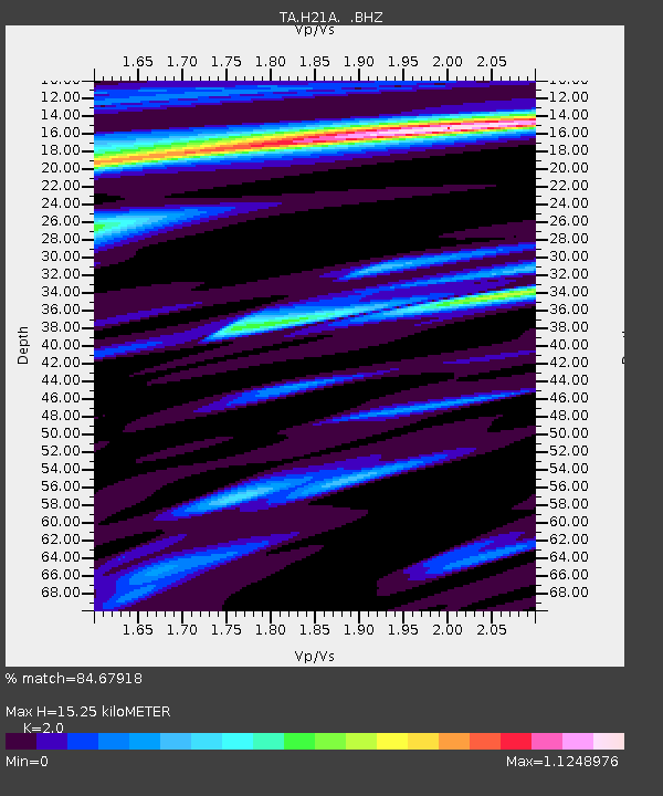
| Estimated Moho Depth: |
15.25 km |
| Estimated Crust Vp/Vs: |
2.00 |
| Assumed Crust Vp: |
6.178 km/s |
| Estimated Crust Vs: |
3.089 km/s |
| Estimated Crust Poisson's Ratio: |
0.33 |
|
| Radial Match: |
84.67918 % |
| Radial Bump: |
400 |
| Transverse Match: |
73.308365 % |
| Transverse Bump: |
400 |
| SOD ConfigId: |
2560 |
| Insert Time: |
2010-03-06 18:20:21.232 +0000 |
| GWidth: |
2.5 |
| Max Bumps: |
400 |
| Tol: |
0.001 |
|
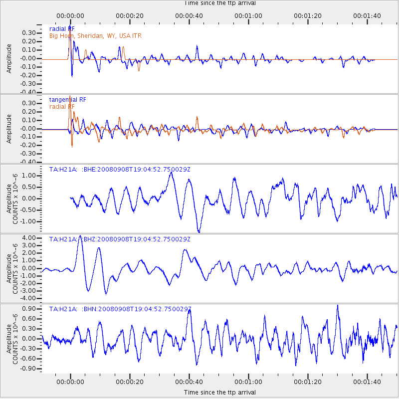
Signal To Noise
| Channel | StoN | STA | LTA |
| TA:H21A: :BHZ:20080908T19:04:52.750029Z | 15.1395235 | 2.2698903E-6 | 1.4993142E-7 |
| TA:H21A: :BHN:20080908T19:04:52.750029Z | 1.0671159 | 1.6410858E-7 | 1.5378703E-7 |
| TA:H21A: :BHE:20080908T19:04:52.750029Z | 2.2692754 | 6.7022705E-7 | 2.9534846E-7 |
| Arrivals |
| Ps | 2.5 SECOND |
| PpPs | 7.3 SECOND |
| PsPs/PpSs | 9.8 SECOND |


