You are here: Home > Network List > TA - USArray Transportable Network (new EarthScope stations) Stations List
> Station G23K Bananza Creek, AK, USA > Earthquake Result Viewer
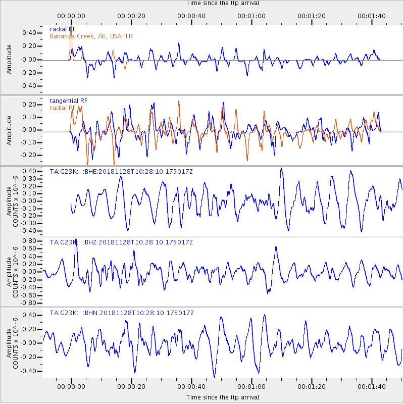
G23K Bananza Creek, AK, USA - Earthquake Result Viewer
*The percent match for this event was below the threshold and hence no stack was calculated.
| Earthquake location: |
Myanmar-India Border Region |
| Earthquake latitude/longitude: |
27.2/96.9 |
| Earthquake time(UTC): |
2018/11/28 (332) 10:17:06 GMT |
| Earthquake Depth: |
11 km |
| Earthquake Magnitude: |
5.4 Mww |
| Earthquake Catalog/Contributor: |
NEIC PDE/us |
|
| Network: |
TA USArray Transportable Network (new EarthScope stations) |
| Station: |
G23K Bananza Creek, AK, USA |
| Lat/Lon: |
66.71 N/150.02 W |
| Elevation: |
746 m |
|
| Distance: |
73.8 deg |
| Az: |
22.391 deg |
| Baz: |
301.431 deg |
| Ray Param: |
$rayparam |
*The percent match for this event was below the threshold and hence was not used in the summary stack. |
|
| Radial Match: |
43.981045 % |
| Radial Bump: |
335 |
| Transverse Match: |
56.7936 % |
| Transverse Bump: |
400 |
| SOD ConfigId: |
13570011 |
| Insert Time: |
2019-05-01 23:04:51.441 +0000 |
| GWidth: |
2.5 |
| Max Bumps: |
400 |
| Tol: |
0.001 |
|
Signal To Noise
| Channel | StoN | STA | LTA |
| TA:G23K: :BHZ:20181128T10:28:10.175017Z | 2.366444 | 3.5380828E-7 | 1.4951051E-7 |
| TA:G23K: :BHN:20181128T10:28:10.175017Z | 0.54958516 | 1.1023201E-7 | 2.0057313E-7 |
| TA:G23K: :BHE:20181128T10:28:10.175017Z | 1.318946 | 2.0288783E-7 | 1.5382572E-7 |
| Arrivals |
| Ps | |
| PpPs | |
| PsPs/PpSs | |


