You are here: Home > Network List > TA - USArray Transportable Network (new EarthScope stations) Stations List
> Station H21A Big Horn, Sheridan, WY, USA > Earthquake Result Viewer
H21A Big Horn, Sheridan, WY, USA - Earthquake Result Viewer
*The percent match for this event was below the threshold and hence no stack was calculated.
| Earthquake location: |
Tonga Islands |
| Earthquake latitude/longitude: |
-18.4/-175.4 |
| Earthquake time(UTC): |
2008/10/22 (296) 12:55:57 GMT |
| Earthquake Depth: |
233 km |
| Earthquake Magnitude: |
5.9 MB, 6.4 MW, 6.3 MW |
| Earthquake Catalog/Contributor: |
WHDF/NEIC |
|
| Network: |
TA USArray Transportable Network (new EarthScope stations) |
| Station: |
H21A Big Horn, Sheridan, WY, USA |
| Lat/Lon: |
44.63 N/107.04 W |
| Elevation: |
1411 m |
|
| Distance: |
88.2 deg |
| Az: |
41.59 deg |
| Baz: |
241.96 deg |
| Ray Param: |
$rayparam |
*The percent match for this event was below the threshold and hence was not used in the summary stack. |
|
| Radial Match: |
62.24634 % |
| Radial Bump: |
400 |
| Transverse Match: |
57.02178 % |
| Transverse Bump: |
330 |
| SOD ConfigId: |
2560 |
| Insert Time: |
2010-03-06 18:21:02.545 +0000 |
| GWidth: |
2.5 |
| Max Bumps: |
400 |
| Tol: |
0.001 |
|
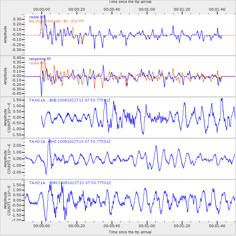
Signal To Noise
| Channel | StoN | STA | LTA |
| TA:H21A: :BHZ:20081022T13:07:50.77501Z | 3.5649467 | 1.4044473E-6 | 3.9396025E-7 |
| TA:H21A: :BHN:20081022T13:07:50.77501Z | 1.5332001 | 1.0904553E-6 | 7.112282E-7 |
| TA:H21A: :BHE:20081022T13:07:50.77501Z | 1.8454663 | 5.3214836E-7 | 2.883544E-7 |
| Arrivals |
| Ps | |
| PpPs | |
| PsPs/PpSs | |


