You are here: Home > Network List > TA - USArray Transportable Network (new EarthScope stations) Stations List
> Station K15K Wolf Creek Mountain, AK, USA > Earthquake Result Viewer
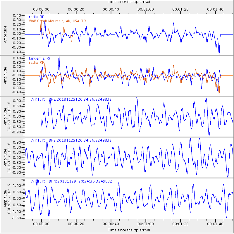
K15K Wolf Creek Mountain, AK, USA - Earthquake Result Viewer
*The percent match for this event was below the threshold and hence no stack was calculated.
| Earthquake location: |
Northern Sumatra, Indonesia |
| Earthquake latitude/longitude: |
0.3/97.0 |
| Earthquake time(UTC): |
2018/11/29 (333) 20:21:44 GMT |
| Earthquake Depth: |
8.8 km |
| Earthquake Magnitude: |
5.7 Mww |
| Earthquake Catalog/Contributor: |
NEIC PDE/us |
|
| Network: |
TA USArray Transportable Network (new EarthScope stations) |
| Station: |
K15K Wolf Creek Mountain, AK, USA |
| Lat/Lon: |
62.29 N/161.53 W |
| Elevation: |
346 m |
|
| Distance: |
95.1 deg |
| Az: |
27.383 deg |
| Baz: |
280.249 deg |
| Ray Param: |
$rayparam |
*The percent match for this event was below the threshold and hence was not used in the summary stack. |
|
| Radial Match: |
57.197716 % |
| Radial Bump: |
400 |
| Transverse Match: |
48.895973 % |
| Transverse Bump: |
370 |
| SOD ConfigId: |
13570011 |
| Insert Time: |
2019-05-01 23:09:50.749 +0000 |
| GWidth: |
2.5 |
| Max Bumps: |
400 |
| Tol: |
0.001 |
|
Signal To Noise
| Channel | StoN | STA | LTA |
| TA:K15K: :BHZ:20181129T20:34:36.324983Z | 1.6389428 | 5.0809393E-7 | 3.1001318E-7 |
| TA:K15K: :BHN:20181129T20:34:36.324983Z | 1.9921592 | 8.476576E-7 | 4.254969E-7 |
| TA:K15K: :BHE:20181129T20:34:36.324983Z | 1.1013818 | 4.2718383E-7 | 3.8786172E-7 |
| Arrivals |
| Ps | |
| PpPs | |
| PsPs/PpSs | |


